Select units of measurement for the temperature and rainfall tables (metric or imperial).
Average weather, temperature, rainfall, sunshine hours

The climate of Port Macquarie is
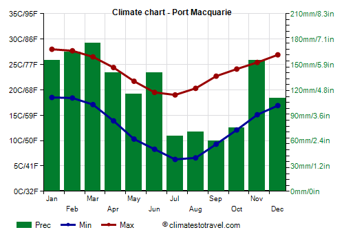
humid subtropical, with very mild winters (from June to August) and warm, rainy summers (from December to March). Rainfall is abundant, amounting to about 1,500 millimeters (60 inches) per year, and varies greatly from year to year. Generally, there is a relatively dry period from July to October. Being in the southern hemisphere, the seasons are reversed compared to the northern hemisphere.
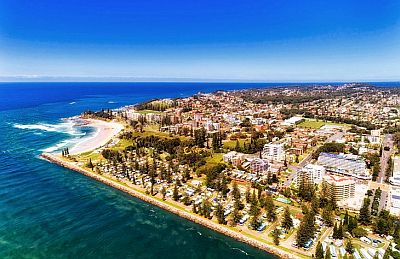
The city is located on the southeastern coast of Australia, in New South Wales, 300 km (185 mi) northeast of Sydney.
West of the city there are
mountains that reach about 1,100 meters (3,600 feet) in height and belong to the Great Dividing Range, which runs through the eastern part of Australia.

Winter, from June to August, is very mild, however,
cold air can sometimes arrive from the south and lower the temperature, especially at night, when it can drop to about 0 °C (32 °F). The coldest record is -3.5 °C (25.7 °F) and was set in late May 2019.
On the other hand, in spring and summer there can be
heatwaves from the desert, although they usually last for a short time (sometimes only a day or two), and in the evening, the breeze from the ocean lower the temperature again. From late September to late February, the records reach or exceed 38 °C (100.5 °F). In February 2017, the temperature even reached 46.6 °C (115.9 °F), although only for one day.
Generally, this area of New South Wales is not directly affected by
tropical cyclones, which only affect the northern part of the state (see Byron Bay, Ballina), however, sometimes the remnants of a weakened cyclone can arrive here, bringing heavy rains. Cyclones typically form from mid-November to mid-May, but are more likely from January to March.
Best Time
To visit Port Macquarie you can choose the period from July to October, since it is the driest of the year. It must be said that sometimes it can get cold at night, especially in July and August. So the best period is spring, in September and October, even though from mid-September onwards, it can get very hot every now and then.
The sea in winter is very cool for swimming, as the ocean temperature is around 20 °C (68 °F), while it is warm enough for swimming from December to April.
Port Macquarie - Climate data
In Port Macquarie, the
average temperature of the coldest month (July) is of
12.6 °C, that of the warmest month (January) is of
23.2 °C. Here are the average temperatures.
Port Macquarie - Average temperatures (1995-2020) |
| Month | Min | Max | Mean |
|---|
| January | 18.5 | 28 | 23.2 |
|---|
| February | 18.4 | 27.7 | 23 |
|---|
| March | 17.1 | 26.5 | 21.8 |
|---|
| April | 13.9 | 24.4 | 19.2 |
|---|
| May | 10.3 | 21.7 | 16 |
|---|
| June | 8.3 | 19.5 | 13.9 |
|---|
| July | 6.3 | 19 | 12.6 |
|---|
| August | 6.6 | 20.3 | 13.4 |
|---|
| September | 9.3 | 22.7 | 16 |
|---|
| October | 12.1 | 24.1 | 18.1 |
|---|
| November | 15.1 | 25.4 | 20.2 |
|---|
| December | 16.9 | 26.9 | 21.9 |
|---|
| Year | 12.7 | 23.8 | 18.25 |
|---|
amounts to
1415 millimeters per year: it is therefore quite abundant. It ranges from
60 millimeters in the driest month (September) to
175 millimeters in the wettest one (March). Here is the average precipitation.
Port Macquarie - Average precipitation| Month | Days |
|---|
| January | 155 | 9 |
|---|
| February | 165 | 11 |
|---|
| March | 175 | 11 |
|---|
| April | 140 | 9 |
|---|
| May | 115 | 8 |
|---|
| June | 140 | 8 |
|---|
| July | 65 | 6 |
|---|
| August | 70 | 5 |
|---|
| September | 60 | 6 |
|---|
| October | 75 | 8 |
|---|
| November | 155 | 10 |
|---|
| December | 110 | 10 |
|---|
| Year | 1415 | 100 |
|---|
The
sea temperature ranges from
20 °C in July, August, September to
25 °C in February, March. Here are the average sea temperatures.
Port Macquarie - Sea temperature| Month |
|---|
| January | 24.5 |
|---|
| February | 25 |
|---|
| March | 25 |
|---|
| April | 24 |
|---|
| May | 22.5 |
|---|
| June | 21 |
|---|
| July | 20 |
|---|
| August | 20 |
|---|
| September | 20 |
|---|
| October | 21 |
|---|
| November | 22"> |
|---|
| December | 23.5 |
|---|
| Year | 22.4 |
|---|