Select units of measurement for the temperature and rainfall tables (metric or imperial).
Average weather, temperature, rainfall, sunshine hours

The climate of Byron Bay is
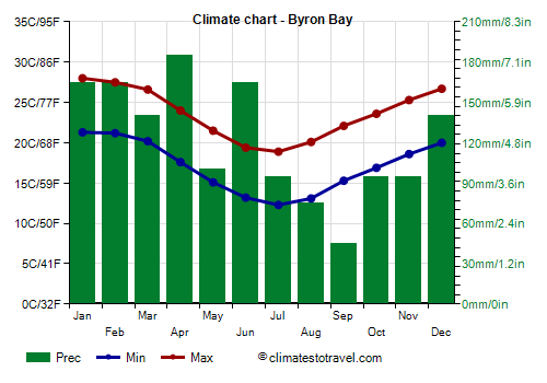
humid subtropical, with very mild winters (from June to August) and hot, rainy summers (from December to March). The rains are more abundant in the hot period, but also in June, the first winter month. Being in the southern hemisphere, the seasons are reversed compared to the northern hemisphere.
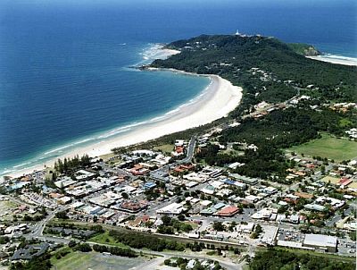
The town is located on the east coast of Australia, in northeastern New South Wales, at 28 degrees south latitude. Nearby Cape Byron is the easternmost part of Australia. To the north, in Queensland, are Brisbane and the Gold Coast.

Due to the location near a cape, very exposed to the winds from the ocean, the climate is particularly mild, and both summer heat waves and cold winter nights are rare.
This area can be affected by
tropical cyclones, although more rarely and with less significant effects than the northern part of Queensland. Cyclones typically form from mid-November to mid-May, but are more likely from January to late March.
Best Time
Given that it has a good climate, you can visit Byron Bay all year round. However, you can choose winter and early spring, ie
from July to September, since it is the mildest and driest time of the year.
Summer is hot and muggy, but the heat is generally bearable, and it's a good period for swimming and sunbathing; sometimes, however, there can be severe thunderstorms, and even a cyclone can approach the city.
For
swimming and surfing, the ocean temperature is higher from December to April, while from June to October, the sea is a bit cool.
Byron Bay - Climate data
In Byron Bay, the
average temperature of the coldest month (July) is of
15.6 °C, that of the warmest month (January) is of
24.6 °C. Here are the average temperatures.
Byron Bay - Average temperatures (2002-2020) |
| Month | Min | Max | Mean |
|---|
| January | 21.3 | 28 | 24.6 |
|---|
| February | 21.2 | 27.5 | 24.4 |
|---|
| March | 20.2 | 26.6 | 23.4 |
|---|
| April | 17.6 | 24 | 20.8 |
|---|
| May | 15.1 | 21.5 | 18.3 |
|---|
| June | 13.2 | 19.4 | 16.3 |
|---|
| July | 12.3 | 18.9 | 15.6 |
|---|
| August | 13.1 | 20.1 | 16.6 |
|---|
| September | 15.3 | 22.1 | 18.7 |
|---|
| October | 16.9 | 23.6 | 20.2 |
|---|
| November | 18.6 | 25.3 | 22 |
|---|
| December | 20 | 26.7 | 23.4 |
|---|
| Year | 17 | 23.6 | 20.3 |
|---|
amounts to
1510 millimeters per year: it is therefore abundant. It ranges from
45 millimeters in the driest month (September) to
185 millimeters in the wettest one (April). Here is the average precipitation.
Byron Bay - Average precipitation| Month | Days |
|---|
| January | 165 | 10 |
|---|
| February | 165 | 12 |
|---|
| March | 140 | 14 |
|---|
| April | 185 | 12 |
|---|
| May | 100 | 10 |
|---|
| June | 165 | 11 |
|---|
| July | 95 | 9 |
|---|
| August | 75 | 6 |
|---|
| September | 45 | 6 |
|---|
| October | 95 | 9 |
|---|
| November | 95 | 8 |
|---|
| December | 140 | 10 |
|---|
| Year | 1510 | 117 |
|---|
The
sea temperature ranges from
21 °C in August to
26.5 °C in February. Here are the average sea temperatures.
Byron Bay - Sea temperature| Month |
|---|
| January | 26 |
|---|
| February | 26.5 |
|---|
| March | 26 |
|---|
| April | 25 |
|---|
| May | 24 |
|---|
| June | 22.5 |
|---|
| July | 21.5 |
|---|
| August | 21 |
|---|
| September | 21.5 |
|---|
| October | 22.5 |
|---|
| November | 23.5"> |
|---|
| December | 25 |
|---|
| Year | 23.8 |
|---|