Select units of measurement for the temperature and rainfall tables (metric or imperial).
Average weather, temperature, rainfall, sunshine hours

The climate of Tinogasta is
subtropical desert, with dry, mild winters (but during which it can get cold at night), and very hot, sunny summers. In addition, the climate is subject to sudden changes in temperature.
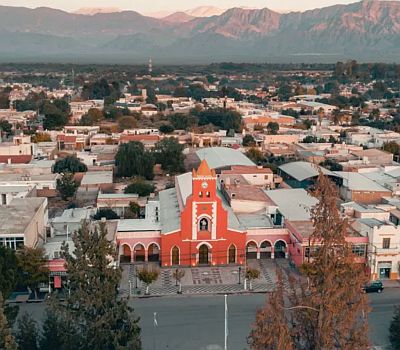
The city is located in the northwest of Argentina, in the province of Catamarca, at 28 degrees south latitude, in a valley on the eastern slope of the Andes, and at 1,200 meters (3,900 feet) above sea level.
The climate is warmer than the altitude might suggest. In addition, it is particularly arid. The sun often shines all year round.
In
winter, from mid-May to mid-August, the difference in temperature between night and day is often noticeable, and, night frosts are quite frequent. During outbreaks cold air from the south, the temperature can drop to -5 °C (23 °F) or below at night and can remain around 10 °C (50 °F) during the day. The record is -10.6 °C (12.9 °F), set in July 1975.

Since winters are dry, snow in Tinogasta is rare, although snowfall can occur from time to time, as in July 2010 and 2013.
On the other hand, the wind that comes down from the mountains, called Zonda and similar to the Föhn and the Chinook, is able to raise the temperature by several degrees, it is no coincidence that the heat records exceed 35 °C (95 °F) even in winter.
In spring, starting from mid-August, the temperature rises, and despite the altitude it can get very hot. Furthermore, in
summer, from December to February, there can be heat waves, during which the temperature can sometimes reach 43/44 °C (109/111 °F). Even in summer, however, there can be outbursts of cool air from the south, perhaps accompanied by a thunderstorm, which can greatly lower the temperature for two or three days, so much so that at night it can be very cool even in midsummer.

In the Andes to the west of Tinogasta there are very high peaks. About 135 km (85 mi) to the northwest, on the border with Chile, is the
Nevado Ojos del Salado, which at 6,893 meters (22,615 ft) is the second highest peak in South America (after Aconcagua) and the highest volcano in the world, while further south is
Monte Pissis, 6,792 meters (22,283 ft) high, and
Cerro Bonete, 6,759 meters (22,175 ft) high.
In this part of the Andes, the climate is semi-arid, however, in summer there can be some rain (and snow in the high mountains).
The
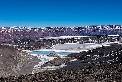
tourist attractions accessible from Tinogasta, which include spectacular desert landscapes, hot springs and colorful lakes, are located at higher altitudes than the city. They are accessible via the Ruta Nacional 60. The town of Fiambalá is located at 1,500 meters (4,900 ft). The
Termas de Fiambalá are located at 1,900 meters (6,200 ft). The
Quebrada de las Angosturas is located at 2,500 meters (8,200 ft). The road already exceeds 3,200 meters (10,500 ft) in Los Seismiles. Further west, near the mountain ranges, the
Balcón del Pissis is located at 4,500 meters (14,700 ft). The road reaches up to 4,748 meters (15,577 ft) in the
Paso de San Francisco, on the border with Chile.
Best Time
It is difficult to find the best time to visit Tinogasta. Summer is very hot, and sometimes thunderstorms can break out. Winter is dry and sunny, with pleasant daytime temperatures, but there can be sudden changes in temperature, and it is usually cold at night, and there can be quite intense frosts. You can then choose the period
from mid-April to mid-May, when the temperature is halfway between winter and summer.
In the
high mountain areas, the best period in terms of temperature is the mildest, between December and March, although rainfall can sometimes block the roads. You can then choose the months of October, November and April, when it is a little colder but the rains are rarer.
If you want, however, you can also choose the winter, since it is a dry and sunny season, but at high altitudes it gets cold, normally below freezing at night, while during the day, with the sun, the temperature increases a lot, normally exceeding the freezing point.
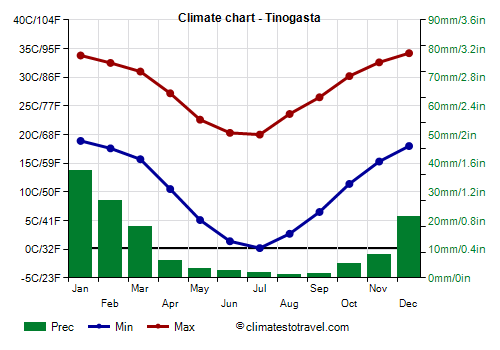
Tinogasta - Climate data
In Tinogasta, the
average temperature of the coldest month (July) is of
10.1 °C, that of the warmest month (January) is of
26.4 °C. Here are the average temperatures.
Tinogasta - Average temperatures (1991-2020) |
| Month | Min | Max | Mean |
|---|
| January | 18.9 | 33.8 | 26.4 |
|---|
| February | 17.6 | 32.5 | 25 |
|---|
| March | 15.7 | 31 | 23.4 |
|---|
| April | 10.5 | 27.2 | 18.8 |
|---|
| May | 5.1 | 22.6 | 13.8 |
|---|
| June | 1.4 | 20.3 | 10.8 |
|---|
| July | 0.2 | 20 | 10.1 |
|---|
| August | 2.7 | 23.6 | 13.2 |
|---|
| September | 6.5 | 26.5 | 16.5 |
|---|
| October | 11.4 | 30.2 | 20.8 |
|---|
| November | 15.3 | 32.6 | 24 |
|---|
| December | 18 | 34.2 | 26.1 |
|---|
| Year | 10.2 | 27.9 | 19 |
|---|
amounts to
135 millimeters per year: it is therefore at a desert level. It ranges from
1.2 millimeters in the driest month (August) to
37.4 millimeters in the wettest one (January). Here is the average precipitation.
Tinogasta - Average precipitation| Month | Days |
|---|
| January | 37 | 5 |
|---|
| February | 27 | 4 |
|---|
| March | 18 | 3 |
|---|
| April | 6 | 1 |
|---|
| May | 3 | 1 |
|---|
| June | 2 | 0 |
|---|
| July | 2 | 1 |
|---|
| August | 1 | 0 |
|---|
| September | 2 | 1 |
|---|
| October | 5 | 1 |
|---|
| November | 8 | 1 |
|---|
| December | 21 | 3 |
|---|
| Year | 135 | 20 |
|---|