On this page, we will give a brief introduction to
Indian monsoon.
During the winter, cool and dry currents from the northeast dominate. Starting from February, temperatures increase rapidly, and already in April and May, there is an increase in instability, with afternoon showers and thunderstorms in the north-east and in the southern areas.
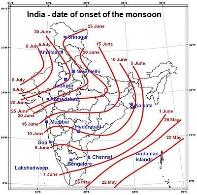
As can be seen in the image above, the real monsoon, brought by the southwest currents, arrives from the beginning of June to the beginning of July depending on the area.
The
southwest monsoon is most intense on the west coast and at the foothills of the Western Ghats, at the foothills of the Himalayas to the east of Nepal and in the northeast, while bringing less abundant rains to the northwest, in the central-southern inland areas and along the south-eastern coast.
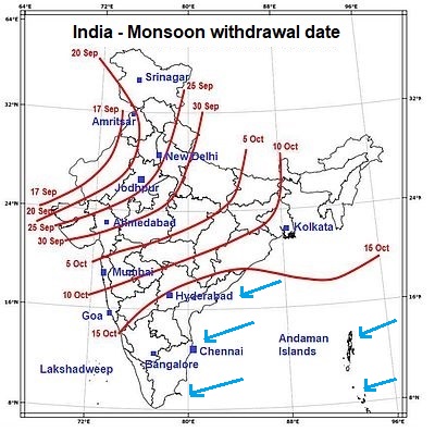
The monsoon lasts until September, when it begins to retreat following the reverse path: it retreats first in the north-west, the last area where it had arrived. Here are the approximate dates of the monsoon retreat (there may be differences from one year to another).

However, it is not over because some areas are affected by the
retreating monsoon. In fact, the north-east wind that blows by October is cooler and drier in the center-north, but along the south-east coast (see the blue arrows), it is capable of bringing abundant rains after being loaded with humidity on the Bay of Bengal. So, on this stretch of coast, where the city of Chennai is located, the wettest period is from October to December.
The Nicobar Islands and Andaman Islands, which are located in the Bay of Bengal, also experience this autumn monsoon, which lasts until December in the Andaman and even mid-January in the Nicobar Islands, which are located more to the south. The same applies for the Laccadive Islands, to the south-west of the Malabar coast.