![]() Climate chart - Utqiagvik (Alaska)
Climate chart - Utqiagvik (Alaska)
On the north coast of Alaska, in Utqiagvik (formerly Barrow), at 71 degrees north latitude, there is an
arctic climate, with very low temperatures, which slightly exceed freezing only in summer.
Nearby is Point Barrow (or Nuvuk), the northernmost point of Alaska and the United States.
 Fog
Fog can form all year round, and in winter it can freeze, producing the phenomenon known as soft rime.
The
wind can blow all year round, but especially in autumn and winter, increasing the feeling of cold.
Since the climate is arid,
snowfalls are not abundant. On average, 115 cm (46 in) of snow fall per year. It typically snows from September to May, however, it can sometimes snow in the summer as well.
In this area, very low temperatures can be reached, though not as in the interior of Alaska, in fact, the post-war cold
record is -48 °C (-54 °F), while further south it is lower than -50 °C (-58 °F).
In summer there may be short periods, maybe just two days, in which the temperature can reach or exceed 20 °C (68 °F).
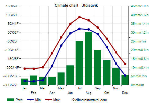
The average temperature ranges from -24.5 °C (-12 °F) in February to 5.5 °C (42 °C) in July. Here are the average temperatures.
Utqiagvik - Average temperatures (1991-2020) | Month | Min (°C) | Max (°C) | Mean (°C) | Min (°F) | Max (°F) | Mean (°F) |
|---|
| January | -27.7 | -20.7 | -24.2 | -18 | -5 | -11.6 |
|---|
| February | -27.9 | -20.9 | -24.4 | -18 | -6 | -11.9 |
|---|
| March | -27.3 | -19.9 | -23.6 | -17 | -4 | -10.5 |
|---|
| April | -19.2 | -11.9 | -15.6 | -3 | 11 | 4 |
|---|
| May | -7.5 | -2.8 | -5.2 | 18 | 27 | 22.7 |
|---|
| June | -0.5 | 5 | 2.2 | 31 | 41 | 36 |
|---|
| July | 2 | 8.7 | 5.4 | 36 | 48 | 41.6 |
|---|
| August | 1.7 | 6.9 | 4.3 | 35 | 44 | 39.7 |
|---|
| September | -1 | 2.8 | 0.9 | 30 | 37 | 33.6 |
|---|
| October | -8.4 | -3.6 | -6 | 17 | 26 | 21.2 |
|---|
| November | -17.8 | -11.4 | -14.6 | 0 | 11 | 5.7 |
|---|
| December | -24.6 | -18 | -21.3 | -12 | 0 | -6.3 |
|---|
| Year | -13.1 | -7.1 | -10.1 | 8.4 | 19.3 | 14 |
|---|
In this coastal area of the north,
precipitation occurs mostly in the form of snow, except in summer, and it is very scarce, in fact, it is slightly higher than 100 millimeters (4 inches) per year. Here is the average precipitation in Utqiagvik.
Utqiagvik - Average precipitation| Month | Millimeters | Inches | Days |
|---|
| January | 4 | 0.1 | 1 |
|---|
| February | 5 | 0.2 | 2 |
|---|
| March | 4 | 0.2 | 1 |
|---|
| April | 4 | 0.2 | 1 |
|---|
| May | 7 | 0.3 | 2 |
|---|
| June | 11 | 0.4 | 3 |
|---|
| July | 25 | 1 | 6 |
|---|
| August | 28 | 1.1 | 7 |
|---|
| September | 20 | 0.8 | 6 |
|---|
| October | 14 | 0.5 | 5 |
|---|
| November | 9 | 0.4 | 3 |
|---|
| December | 6 | 0.2 | 2 |
|---|
| Year | 135 | 5.4 | 40 |
|---|
In Utqiagvik, the
sun remains below the horizon for a couple of months, from November 18 to January 22, while it never sets from May 10 to August 2. In late spring and in summer, the sun is seen for a good number of hours, also because of the very long days. However, in this period, in addition to rainy days, as mentioned, sometimes fog can form.
Utqiagvik - Sunshine hours| Month | Average | Total |
|---|
January | 0 | 0 | February | 3 | 85 | March | 6 | 185 | April | 9 | 270 | May | 10 | 310 | June | 10 | 300 | July | 10 | 310 | August | 6 | 185 | September | 4 | 120 | October | 2 | 60 | November | 1 | 30 | December | 0 | 0 | Year | 5.1 | 1860 |
On the north coast, the Arctic Ocean is frozen solid for many months of the year, and is typically ice-free from mid-July to late October. Remember that the sea freezes at about -2 °C (28 °F).
Utqiagvik - Sea temperature| Month | Celsius (°C) | Fahrenheit (°F) |
|---|
January | -1.5 | 29 | February | -1.5 | 29 | March | -2 | 29 | April | -1.5 | 29 | May | -1.5 | 29 | June | -1 | 30 | July | 0.5 | 33 | August | 2 | 36 | September | 2 | 35 | October | 0.5 | 33 | November | -1 | 30 | December | -1.5 | 29 | Year | -0.6 | 30.9 |
Best Time
The best time to visit Utqiagvik is the
summer, in July and August, since they are the least cold months. In June the temperatures are lower, but the sun is always above the horizon, while in August the days begin to get shorter.
Utqiagvik - Weather by month
Based on the period 1991-2020
January is generally a freezing cold month. The average temperature is of -24.2 °C (-12 °F), with a minimum of -27.7 °C (-17.9 °F) and a maximum of -20.7 °C (-5.3 °F).

On the coldest nights of the month, the temperature usually drops to around -38.5 °C (-37.5 °F). However, it dropped to -45 °C (-49 °F) in January 1993.

On the warmest days of the month, the temperature usually reaches around -7 °C (19.5 °F). However, it reached 2.2 °C (36 °F) in January 2017.

Precipitation amounts to only 4 mm (0.2 in), and all occurs in one day.
The day lasts on average 1 hour and 5 minutes. So the days are very short.

There are on average 0 hours of sunshine per day. So, the sun shines 0% of the time.
The average humidity is 79%. Hence, the air is normally humid.
The average wind speed is 21 kph (13 mph).

The average sea temperature is of -1.5 °C (29 °F). Therefore, the sea is very cold for swimming.
February, the coldest month of the year, is generally a freezing cold month. The average temperature is of -24.4 °C (-12 °F), with a minimum of -27.9 °C (-18.2 °F) and a maximum of -20.9 °C (-5.6 °F).
On the coldest nights of the month, the temperature usually drops to around -39.5 °C (-39 °F). However, it dropped to -48.3 °C (-54.9 °F) in February 2006.
On the warmest days of the month, the temperature usually reaches around -8 °C (18 °F). However, it reached 2 °C (35.6 °F) in February 2006.
Precipitation amounts to only 5 mm (0.2 in), distributed over 2 days.
The day lasts on average 7 hours and 5 minutes. So the days are short.
There are on average 3 hours of sunshine per day. So, the sun shines 42% of the time.
The average humidity is 79%. Hence, the air is normally humid.
The average wind speed is 21 kph (13 mph).
The average sea temperature is of -1.5 °C (29 °F). Therefore, the sea is very cold for swimming.
March is generally a freezing cold month. The average temperature is of -23.6 °C (-10 °F), with a minimum of -27.3 °C (-17.1 °F) and a maximum of -19.9 °C (-3.8 °F).
On the coldest nights, the temperature usually drops to around -38 °C (-36.5 °F). However, it dropped to -43.4 °C (-46.1 °F) in March 1995.
On the warmest days, the temperature usually reaches around -8 °C (17.5 °F). However, it reached 1.1 °C (34 °F) in March 2019.
Precipitation amounts to only 4 mm (0.2 in), and all occurs in one day.
The day lasts on average 11 hours and 55 minutes.
There are on average 6 hours of sunshine per day. So, the sun shines 50% of the time.
The average humidity is 79%. Hence, the air is normally humid.
The average wind speed is 19 kph (12 mph).
The average sea temperature is of -2 °C (29 °F). Therefore, the sea is very cold for swimming.
April is generally a freezing cold month. The average temperature is of -15.6 °C (4 °F), with a minimum of -19.2 °C (-2.6 °F) and a maximum of -11.9 °C (10.6 °F).
On the coldest nights, the temperature usually drops to around -30.5 °C (-22.5 °F). However, it dropped to -37.8 °C (-36 °F) in April 1991.
On the warmest days, the temperature usually reaches around -2 °C (28 °F). However, it reached 4.4 °C (39.9 °F) in April 2019.
Precipitation amounts to only 4 mm (0.2 in), and all occurs in one day.
The day lasts on average 16 hours and 55 minutes.
There are on average 9 hours of sunshine per day. So, the sun shines 53% of the time.
The average humidity is 83%. Hence, the air is normally humid.
The average wind speed is 19 kph (12 mph).
The average sea temperature is of -1.5 °C (29 °F). Therefore, the sea is very cold for swimming.
May is generally a freezing cold month. The average temperature is of -5.2 °C (23 °F), with a minimum of -7.5 °C (18.5 °F) and a maximum of -2.8 °C (27 °F).
On the coldest nights, the temperature usually drops to around -18 °C (0 °F). However, it dropped to -27 °C (-16.6 °F) in May 2001.
On the warmest days, the temperature usually reaches around 3.5 °C (38.5 °F). However, it reached 8.3 °C (46.9 °F) in May 1996.
Precipitation amounts to only 7 mm (0.3 in), distributed over 2 days.
The day lasts on average 23 hours and 10 minutes. So the days are very long.
There are on average 10 hours of sunshine per day. So, the sun shines 43% of the time.
The average humidity is 88%. Hence, the air is normally humid.
The average wind speed is 20 kph (12 mph).
The average sea temperature is of -1.5 °C (29.5 °F). Therefore, the sea is very cold for swimming.
June is generally a cold month. The average temperature is of 2.2 °C (36 °F), with a minimum of -0.5 °C (31.1 °F) and a maximum of 5 °C (41 °F).
On the coldest nights, the temperature usually drops to around -4.5 °C (23.5 °F). However, it dropped to -11.2 °C (11.8 °F) in June 1994.
On the warmest days, the temperature usually reaches around 15 °C (59 °F). However, it reached 22.8 °C (73 °F) in June 2019.
Precipitation amounts to 11 mm (0.4 in), distributed over 3 days.
The day lasts on average 24 hours. So the sun is always above the horizon.
There are on average 10 hours of sunshine per day. So, the sun shines 42% of the time.
The average humidity is 87%. Hence, the air is normally humid.
The average wind speed is 20 kph (12 mph).
The average sea temperature is of -1 °C (30 °F). Therefore, the sea is very cold for swimming.
July, the least cold month of the year, is generally a quite cold month. The average temperature is of 5.4 °C (42 °F), with a minimum of 2 °C (35.6 °F) and a maximum of 8.7 °C (47.7 °F).
On the coldest nights of the month, the temperature usually drops to around -1.5 °C (29.5 °F). However, it dropped to -4 °C (24.8 °F) in July 2002.
On the warmest days of the month, the temperature usually reaches around 18.5 °C (65.5 °F). However, it reached 26.1 °C (79 °F) in July 1993.
Precipitation amounts to 25 mm (1 in), distributed over 6 days.
The day lasts on average 24 hours. So the sun is always above the horizon.
There are on average 10 hours of sunshine per day. So, the sun shines 42% of the time.
The average humidity is 87%. Hence, the air is normally humid.
The average wind speed is 20 kph (12 mph).
The average sea temperature is of 0.5 °C (33.5 °F). Therefore, the sea is very cold for swimming.
August is generally a quite cold month. The average temperature is of 4.3 °C (40 °F), with a minimum of 1.7 °C (35.1 °F) and a maximum of 6.9 °C (44.4 °F).
On the coldest nights of the month, the temperature usually drops to around -2 °C (28.5 °F). However, it dropped to -6.1 °C (21 °F) in August 1991.
On the warmest days of the month, the temperature usually reaches around 16 °C (61 °F). However, it reached 23 °C (73.4 °F) in August 1999.
Precipitation amounts to 28 mm (1.1 in), distributed over 7 days.
The day lasts on average 18 hours and 35 minutes. So the days are very long.
There are on average 6 hours of sunshine per day. So, the sun shines 32% of the time.
The average humidity is 89%. Hence, the air is normally humid.
The average wind speed is 20 kph (12 mph).
The average sea temperature is of 2 °C (35.5 °F). Therefore, the sea is very cold for swimming.
September is generally a cold month. The average temperature is of 0.9 °C (34 °F), with a minimum of -1 °C (30.2 °F) and a maximum of 2.8 °C (37 °F).
On the coldest nights, the temperature usually drops to around -6 °C (21 °F). However, it dropped to -14.4 °C (6.1 °F) in September 1992.
On the warmest days, the temperature usually reaches around 10.5 °C (51.5 °F). However, it reached 16.7 °C (62.1 °F) in September 1995.
Precipitation amounts to 20 mm (0.8 in), distributed over 6 days.
The day lasts on average 13 hours and 20 minutes.
There are on average 4 hours of sunshine per day. So, the sun shines 30% of the time.
The average humidity is 87%. Hence, the air is normally humid.
The average wind speed is 21 kph (13 mph).
The average sea temperature is of 2 °C (35.5 °F). Therefore, the sea is very cold for swimming.
October is generally a freezing cold month. The average temperature is of -6 °C (21 °F), with a minimum of -8.4 °C (16.9 °F) and a maximum of -3.6 °C (25.5 °F).
On the coldest nights, the temperature usually drops to around -20 °C (-4 °F). However, it dropped to -33 °C (-27.4 °F) in October 1996.
On the warmest days, the temperature usually reaches around 2.5 °C (36.5 °F). However, it reached 8.9 °C (48 °F) in October 2016.
Precipitation amounts to 14 mm (0.6 in), distributed over 5 days.
The day lasts on average 8 hours and 25 minutes.
There are on average 2 hours of sunshine per day. So, the sun shines 24% of the time.
The average humidity is 85%. Hence, the air is normally humid.
The average wind speed is 23 kph (14 mph).
The average sea temperature is of 0.5 °C (32.5 °F). Therefore, the sea is very cold for swimming.
November is generally a freezing cold month. The average temperature is of -14.6 °C (6 °F), with a minimum of -17.8 °C (0 °F) and a maximum of -11.4 °C (11.5 °F).
On the coldest nights, the temperature usually drops to around -28.5 °C (-19.5 °F). However, it dropped to -38.9 °C (-38 °F) in November 1992.
On the warmest days, the temperature usually reaches around -1.5 °C (29.5 °F). However, it reached 4 °C (39.2 °F) in November 2017.
Precipitation amounts to only 9 mm (0.4 in), distributed over 3 days.
The day lasts on average 2 hours and 5 minutes. So the days are very short.
There is an average of 1 hour of sunshine per day. So, the sun shines 48% of the time.
The average humidity is 83%. Hence, the air is normally humid.
The average wind speed is 22 kph (14 mph).
The average sea temperature is of -1 °C (30 °F). Therefore, the sea is very cold for swimming.
December is generally a freezing cold month. The average temperature is of -21.3 °C (-6 °F), with a minimum of -24.6 °C (-12.3 °F) and a maximum of -18 °C (-0.4 °F).
On the coldest nights of the month, the temperature usually drops to around -35.5 °C (-31.5 °F). However, it dropped to -45 °C (-49 °F) in December 1994.
On the warmest days of the month, the temperature usually reaches around -6 °C (21.5 °F). However, it reached 3 °C (37.4 °F) in December 2004.
Precipitation amounts to only 6 mm (0.2 in), distributed over 2 days.
The day lasts on average 0 hours and 0 minutes. So the sun is always below the horizon.
The average humidity is 80%. Hence, the air is normally humid.
The average wind speed is 21 kph (13 mph).
The average sea temperature is of -1.5 °C (29 °F). Therefore, the sea is very cold for swimming.