Select units of measurement for the temperature and rainfall tables (metric or imperial).
Average weather, temperature, rainfall, sunshine hours

The climate of Mammoth Lakes is
moderately continental, with cold, snowy winters and sunny summers, which are warm during the day, but with cool nights.
The town is located in
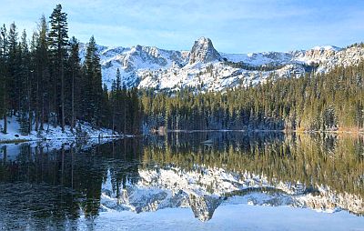
California, at 2,400 meters (7,900 ft) above sea level, in the Sierra Nevada, and south-east of Yosemite National Park. We are near the Mammoth Mountain Ski Area. On average, 5 meters 25 cm (more than 17 feet) of snow fall per year. Usually, it snows from November to April. The wind blows frequently, and can sometimes be strong.

In
winter, on colder nights the temperature drops to -20 °C (-4 °F) or below, but in colder winters it can drop below -30 °C (-22 °F).
In
summer, the temperature can reach and exceed 30 °C (86 °F), especially in the nearby valleys, at around 2,000 meters (6,500 ft). At night, however, it can be cold, so it is better to dress in layers. On rare occasions, thunderstorms can break out in the afternoon.
The
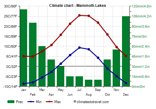
average temperature of the coldest month (January) is of -1.7 °C (28.9 °F), that of the warmest month (July) is of 17.4 °C (63.3 °F). Here are the average temperatures.
Mammoth Lakes - Average temperatures (1991-2020) |
| Month | Min | Max | Mean |
|---|
| January | -8.6 | 5.1 | -1.7 |
|---|
| February | -7.9 | 5 | -1.5 |
|---|
| March | -5.4 | 7.5 | 1 |
|---|
| April | -2.7 | 10.7 | 4 |
|---|
| May | 1.4 | 15.8 | 8.6 |
|---|
| June | 5.7 | 21.3 | 13.5 |
|---|
| July | 9.4 | 25.4 | 17.4 |
|---|
| August | 8.6 | 25.2 | 16.9 |
|---|
| September | 4.3 | 21.8 | 13.1 |
|---|
| October | -1 | 15.9 | 7.5 |
|---|
| November | -4.9 | 9.6 | 2.4 |
|---|
| December | -8.3 | 5.2 | -1.5 |
|---|
| Year | -0.7 | 14.1 | 6.65 |
|---|
amounts to 585 millimeters (23 inches) per year: so, it is at an intermediate level. It ranges from 10 mm (0.4 in) in the driest months (August, September) to 115 mm (4.5 in) in the wettest (January). Here is the average precipitation.
Mammoth Lakes - Average precipitation| Month | Days |
|---|
| January | 115 | 9 |
|---|
| February | 95 | 9 |
|---|
| March | 60 | 6 |
|---|
| April | 40 | 7 |
|---|
| May | 30 | 5 |
|---|
| June | 15 | 3 |
|---|
| July | 15 | 3 |
|---|
| August | 10 | 2 |
|---|
| September | 10 | 2 |
|---|
| October | 40 | 4 |
|---|
| November | 55 | 5 |
|---|
| December | 105 | 8 |
|---|
| Year | 585 | 63 |
|---|
Best Time
The best time to visit Mammoth Lakes is from June to September, as it is the warmest and sunniest period of the year.