Select units of measurement for the temperature and rainfall tables (metric or imperial).
Average weather, temperature, rainfall, sunshine hours
The climate of the Grand Canyon varies greatly depending on the altitude, and is
subtropical semi-desert in the valley floor, with mild winters and hot summers, and
continental in the upper part, with cold, snowy winters and hot summers during the day, but with cool nights.
However, the climate of the different areas has some characteristics in common, such as the
strong difference in temperature between night and day, and the risk of
thunderstorms from July to September, due to the North American monsoon, which usually erupt from late morning to late afternoon. These thunderstorms can swell the smaller watercourses at a distance and without warning.
Grand Canyon National Park is located in the southwestern United States, in Arizona, at 36 degrees north latitude. The canyon was created over the millennia by the
Colorado River, which carved a gorge in the plateau of the same name.

The river flows at 750 meters (2,460 ft) above sea level, and there are two trails, North Kaibab Trail and South Kaibab Trail, which allow you to reach the river, sleeping at the Phantom Ranch, located in a gorge carved out by a tributary.
Here are the average temperatures recorded at the Phantom Ranch, at 760 meters (2,500 ft) above sea level. As you can see, the summer temperatures in the valley floor are very high. Winter is quite mild, however, cold air can settle into the valley, especially in December and January, when the sun is lower.
Inner Canyon - Average temperatures|
| Month | Min | Max | Mean |
|---|
| January | 2 | 13 | 7.5 |
|---|
| February | 6 | 17 | 11.5 |
|---|
| March | 9 | 22 | 15.5 |
|---|
| April | 13 | 28 | 20.5 |
|---|
| May | 17 | 33 | 25 |
|---|
| June | 22 | 38 | 30 |
|---|
| July | 26 | 41 | 33.5 |
|---|
| August | 24 | 39 | 31.5 |
|---|
| September | 21 | 36 | 28.5 |
|---|
| October | 14 | 29 | 21.5 |
|---|
| November | 8 | 20 | 14 |
|---|
| December | 2 | 14 | 8 |
|---|
| Year | 13.7 | 27.6 | 20.6 |
|---|
The park is accessed from the
plateau, where temperatures are much lower. There are three entrances, one on the North Rim and two on the South Rim.
The entrance of the
North Rim, on the edge of the Kaibab Plateau, reachable from Page, Arizona, is the least frequented by tourists and the highest, since it is located at 2,550 meters (8,365 ft) above sea level. Having a colder climate, this part of the park remains open from May 15 to October 15. From October 15 onwards, it is only open for visits from dawn to dusk, while it closes on November 30 or at the first snowfall capable of blocking the road.
The southern border of the park,
South Rim, reachable both from the north (from the aforementioned Page, via Highway 89) and from the south (from Williams and Flagstaff, via Highway 64), is the most popular with tourists, and hosts two entrances, South Entrance and East Entrance. The South Entrance, where we find the
Grand Canyon Village, is located at 2,100 meters (6,900 ft) above sea level. The East Entrance, where the Desert View Watchtower is located, is at 2,280 meters (7,480 ft).
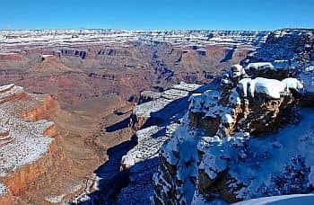
Although the South Rim has a slightly milder climate and is open year-round, for a few months, it can snow and ice can form on the roads.
Here are the average temperatures recorded at the Grand Canyon Village.
Grand Canyon Village - Average temperatures (1991-2020) |
| Month | Min | Max | Mean |
|---|
| January | -7.1 | 6.8 | -0.1 |
|---|
| February | -6.1 | 7.9 | 0.9 |
|---|
| March | -3.9 | 12 | 4.1 |
|---|
| April | -1.8 | 16.1 | 7.1 |
|---|
| May | 2 | 21.1 | 11.5 |
|---|
| June | 6.1 | 27.8 | 16.9 |
|---|
| July | 10.2 | 29.4 | 19.8 |
|---|
| August | 9.9 | 27.8 | 18.9 |
|---|
| September | 6.5 | 24.3 | 15.4 |
|---|
| October | 0.7 | 18.1 | 9.4 |
|---|
| November | -4.1 | 11.8 | 3.9 |
|---|
| December | -7.7 | 6.1 | -0.8 |
|---|
| Year | 0.4 | 17.5 | 8.95 |
|---|
In the Grand Canyon,
precipitation varies, like the temperatures, depending on the altitude. The North Rim, in addition to being the coldest area, is the rainiest, and snowiest in winter, with a total of 640 millimeters (25 in) per year, and a good 360 cm (140 in) of snow. In the upper part it can snow from October to April, and sometimes even in May.
In the valley floor, where the river flows, about 250 mm (10 in) of rain fall per year.
There are
two rainy periods: the cold semester, due to disturbances from the Pacific, which peaks in winter, and the aforementioned summer monsoon, which brings thunderstorms from July to September.
Here is the average rainfall recorded at Grand Canyon Village.
Grand Canyon Village - Average precipitation| Month | Days |
|---|
| January | 45 | 6 |
|---|
| February | 31 | 6 |
|---|
| March | 47 | 6 |
|---|
| April | 16 | 4 |
|---|
| May | 10 | 3 |
|---|
| June | 6 | 2 |
|---|
| July | 59 | 7 |
|---|
| August | 56 | 10 |
|---|
| September | 38 | 6 |
|---|
| October | 31 | 5 |
|---|
| November | 20 | 4 |
|---|
| December | 32 | 6 |
|---|
| Year | 390 | 64 |
|---|
In
winter, during cold spells, on the plateau, the temperature can drop to -20 °C (-4 °F), and occasionally to -30 °C (-22 °F).
In
summer, the temperature can reach 36/37 °C (97/99 °F) in the upper part, and exceed 45 °C (113 °F) in the valley floor.
In summer, you need to protect yourself from the sun's rays, with a hat, sunglasses and sunscreen. To avoid the risk of dehydration, you need to bring plenty of liquids. Also, especially starting in July, you need to be careful of thunderstorms.
In the evening, however, the temperature drops a lot, so you need to bring some warm clothes for the evening and night on the plateau.

About 150 km (93 mi) west of the national park, inside the Hualapai Indian Reservation, is the western part of the Grand Canyon, called
Grand Canyon West, reachable in about two and a half hours from Las Vegas. Here we find the entrance called
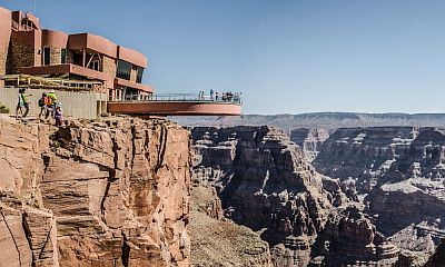
West Rim. In this area there is a small airport, and there are also attractions such as Guano Point and the Skywalk.
The altitude in this area is lower than in the national park, since the plateau, where the entrance is located, is at 1,460 meters (4,790 feet) above sea level, while the river flows at 355 meters (1,165 ft) above sea level.
This means that the climate in Grand Canyon West is milder in winter than in the national park, but even hotter in summer. Furthermore, the climate in this area is more arid.