![]() Climate chart - College Station (Texas)
Climate chart - College Station (Texas)
The climate of College Station is
subtropical, with mild winters and very hot, muggy summers.
The city is located in east-central Texas, in Brazos County, approximately 130 km (80 mi) northwest of Houston and 130 km (80 mi) northeast of Austin.
Winter, from December to February, is mild, but there may be variations in temperature. Even in the middle of winter, there can be hot days, with highs of 25 °C (77 °F) and more. In other circumstances, it can get cold at night, and the temperature can drop below freezing.
Occasionally, there may be real cold waves, which last a few days, during which the temperature can drop to -10 °C (14 °F) or below. In recent decades, the record is -18 °C (0 °F), recorded in December 1989.
Sometimes the dangerous phenomenon of freezing rain can occur.
Snowfall at College Station is rare. In December 2017, 12 centimeters (5 inches) of snow fell. In 2021, 11 cm (4.5 in) fell in January and 8 cm (3 in) in February.
In the
summer, from June to September, the combination of high temperature and humidity makes the heat very unpleasant. On the hottest days, it can reach and exceed 40 °C (104 °F). The record is 44.5 °C (112 °F), recorded in early September 2000.
From time to time, the city can be reached by the remnants of a
hurricane, coming from the Gulf of Mexico or the Pacific. In general, hurricanes weaken when they penetrate inland, however, they can still bring abundant rains. The hurricane season runs from June to November, although they are more likely from August to October, with a peak in September.
College Station is on the edge of the "tornado alley", so tornadoes can occasionally form between April and June (and more rarely in autumn).
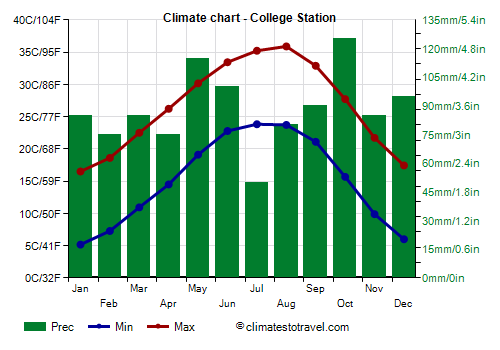
The
average temperature of the coldest month (January) is of 10.8 °C (51.5 °F), that of the warmest month (August) is of 29.8 °C (85.6 °F). Here are the average temperatures.
College Station - Average temperatures (1991-2020) | Month | Min (°C) | Max (°C) | Mean (°C) | Min (°F) | Max (°F) | Mean (°F) |
|---|
| January | 5.2 | 16.5 | 10.8 | 41 | 62 | 51.5 |
|---|
| February | 7.3 | 18.6 | 12.9 | 45 | 65 | 55.3 |
|---|
| March | 10.9 | 22.5 | 16.7 | 52 | 72 | 62.1 |
|---|
| April | 14.5 | 26.2 | 20.4 | 58 | 79 | 68.6 |
|---|
| May | 19.1 | 30.2 | 24.6 | 66 | 86 | 76.4 |
|---|
| June | 22.8 | 33.4 | 28.1 | 73 | 92 | 82.6 |
|---|
| July | 23.8 | 35.2 | 29.5 | 75 | 95 | 85.1 |
|---|
| August | 23.7 | 35.9 | 29.8 | 75 | 97 | 85.6 |
|---|
| September | 21.1 | 32.9 | 27 | 70 | 91 | 80.6 |
|---|
| October | 15.7 | 27.7 | 21.7 | 60 | 82 | 71.1 |
|---|
| November | 9.9 | 21.7 | 15.8 | 50 | 71 | 60.4 |
|---|
| December | 6 | 17.4 | 11.7 | 43 | 63 | 53.1 |
|---|
| Year | 15 | 26.6 | 20.75 | 59.1 | 79.8 | 69.5 |
|---|
amounts to 1,060 millimeters (41.7 inches) per year: so, it is at an intermediate level. It ranges from 50 mm (2 in) in the driest month (July) to 125 mm (4.9 in) in the wettest (October). Here is the average precipitation.
College Station - Average precipitation| Month | Millimeters | Inches | Days |
|---|
| January | 85 | 3.3 | 9 |
|---|
| February | 75 | 3 | 8 |
|---|
| March | 85 | 3.3 | 8 |
|---|
| April | 75 | 3 | 7 |
|---|
| May | 115 | 4.5 | 8 |
|---|
| June | 100 | 3.9 | 8 |
|---|
| July | 50 | 2 | 5 |
|---|
| August | 80 | 3.1 | 6 |
|---|
| September | 90 | 3.5 | 7 |
|---|
| October | 125 | 4.9 | 7 |
|---|
| November | 85 | 3.3 | 8 |
|---|
| December | 95 | 3.7 | 9 |
|---|
| Year | 1060 | 41.7 | 92 |
|---|

Best Time
To visit College Station, you can choose spring and autumn (in particular, from mid-March to mid-April and from mid-October to mid-November), to avoid the summer heat. In winter, there are long mild periods, but some very cold days cannot be excluded.
Return to the climate of
Texas.