Select units of measurement for the temperature and rainfall tables (metric or imperial).
Average weather, temperature, rainfall, sunshine
In South Georgia, an island of the southern Atlantic Ocean administered by the United Kingdom, there is a
maritime subpolar climate, with cold and windy weather all year round.
The island, about 170 km (105 mi) long, is located at almost 55 degrees south latitude, and is exposed to the intense and incessant flow of the
westerly winds, which bring disturbances, able to cause rain or snow throughout the year.
Given the temperatures,
snowfall is more likely to occur from mid-April to October, but it can sometimes occur even in summer and at sea level. Strong winds blow throughout the year, and the humidity is consistently high.
In
inland areas, where hills and mountains are found, the climate gets colder, and given the low summer temperatures, glaciers cover most of the island from an altitude of only 300 meters (1,000 feet), and some glacial tongues descend by gravity to the sea.
With increasing altitude, snowfall becomes more likely even in summer. The highest peak is
Mount Paget, 2,935 meters (9,629 feet) high.

About 500 km (310 mi) to the southeast we find smaller islands, belonging to the same British administration, the
South Sandwich Islands.
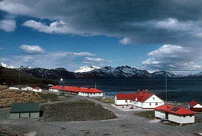
Nearby Grytviken, a former whaling station, is the settlement of
King Edward Point, the de facto capital of South Georgia and the South Sandwiches.
The climate in detail
Temperature and rain
Grytviken

In the small settlement of
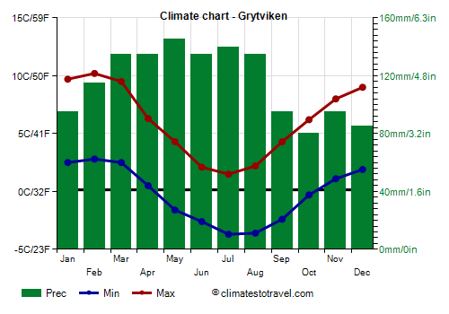
Grytviken, located on the east coast of the island, in a sheltered bay, the average temperature ranges from -1 °C (30 °F) in July to 6.5 °C (43.5 °F) in February.
In
winter, from June to August, after outbreaks of cold air masses from Antarctica, the temperature can drop to -10/-12 °C (10/14 °F). However, after a while, the westerlies usually start to blow again, therefore, severe frost doesn't last long.
In
summer , from December to March, and occasionally also in November, there may be very mild periods, in which the temperature can reach 20/22 °C (68/71.5 °F). In January 2006 it reached 23 °C (73.5 °F).
Annual
precipitation in Grytviken amounts to 1,400 millimeters (55 inches) per year, and it's well distributed over the seasons, although it drops slightly below 100 mm (4 in) per month from September to January, that is, between spring and early summer.
On the other hand, it hovers between 115 and 145 mm (4.5 and 5.7 in) per month between February and August, that is, from late summer to late winter.
In South Georgia, the amount of sunshine is scarce, especially in winter, when the sun is almost never seen.

The
sea is very cold throughout the year, and it approaches the freezing point in winter and spring, reaching 0 °C (32 °F) from August to October. It is useful to recall that the sea, being salty, freezes at about -2 °C (28 °F).
Bird Island
In the areas most exposed to ocean winds, summer is even colder. On the small
Bird Island, located in the extreme west, near the main island, the temperature in February, the mildest month, is only 4 °C (39 °F). Even mild days are rarer, in fact the temperature rarely exceeds 10 °C (50 °F). In February 2021 it reached 13 °C (55.5 °F).
When to go
The best time to visit South Georgia is
the austral summer, from December to March, and especially from January to March, when temperatures are higher.
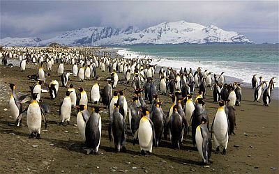
During this period, you will be able to observe various
animal species in reproduction, including penguins, seals and elephant seals, as well as birds such as albatrosses, terns and gulls.
The islands can only be reached
by sea, usually from Ushuaia, Argentina.
It must be said that, even in this period, the weather is often not good: the temperature is low, it can rain, the wind often blows, and in inland hills and mountains (but sometimes, even on the coast), it can snow. It will therefore be useful to bring warm clothes, hoping to have the chance to remove the outer layers on warmer days, when the temperature can approach 20 °C (68 °F).
What to pack
In
winter (June to August): bring warm clothes, a fleece, a down jacket, a wind jacket, a warm hat, gloves, a scarf, a raincoat, and hiking boots.
In
summer (December to March): bring warm clothes, such as a sweater, a raincoat, a down jacket, a hat, and hiking boots; the outwer layer can be removed on warmer days. For inland mountains and Mount Paget, bring warm clothes like in winter.
Climate data - South Georgia
| Bird Island |
|---|
|
| Jan | Feb | Mar | Apr | May | Jun | Jul | Aug | Sep | Oct | Nov | Dec |
|---|
| Min temp. | 2 | 2 | 2 | 1 | -1 | -2 | -2 | -3 | -2 | -1 | 0 | 1 |
|---|
| Max temp. | 5 | 5 | 5 | 4 | 2 | 2 | 1 | 1 | 1 | 2 | 3 | 4 |
|---|
| Precip. | 85 | 80 | 95 | 125 | 110 | 110 | 120 | 115 | 105 | 100 | 90 | 75 |
|---|
|
|
|
|
|
| Grytviken |
|---|
|
| Jan | Feb | Mar | Apr | May | Jun | Jul | Aug | Sep | Oct | Nov | Dec |
|---|
| Min temp. | 2 | 3 | 2 | 0 | -2 | -3 | -4 | -4 | -2 | 0 | 1 | 2 |
|---|
| Max temp. | 10 | 10 | 10 | 6 | 4 | 2 | 2 | 2 | 4 | 6 | 8 | 9 |
|---|
| Precip. | 90 | 115 | 135 | 140 | 135 | 135 | 150 | 150 | 90 | 80 | 95 | 90 |
|---|
| Prec. days | 12 | 13 | 14 | 14 | 12 | 15 | 15 | 14 | 11 | 12 | 11 | 11 |
|---|
|
|
| Sun hours | 5 | 6 | 4 | 2 | 1 | 0 | 1 | 2 | 4 | 6 | 6 | 5 |
|---|
| Sea temp | 3 | 3 | 3 | 3 | 2 | 1 | 1 | 0 | 0 | 0 | 1 | 2 |
|---|