![]() Climate chart - Kopaonik (Serbia)
Climate chart - Kopaonik (Serbia)
In Kopaonik, there is a
cold mountain climate, with very cold winters, during which the temperature is normally below freezing, and cool to mild summers.
The ski resort is located in southern Serbia, at 1,700 meters (5,600 feet), within the national park of the same name, and a short distance from Pancic's peak, 2,017 meters (6,617 ft) high.
In winter, during cold spells, the temperature can drop to -20 °C (-4 °F) or even below. The record is -25 °C (-13 °F), recorded in January 2017.
Summer is mild, with some cold periods but also some quite warm periods. Rains and thunderstorms are quite frequent. Generally the temperature reaches 26/27 °C (79/81 °F) on the hottest days, although in July 2007 it reached 30 °C (86 °F).

Best Time
The best time to visit Kopaonik is the summer, and in particular, the months of July and August, because they are the mildest, although there can be afternoon thunderstorms. Also, since it can get cold at night, it's better to bring a jacket and a sweater even in this period.
Late winter and early spring (February-March) are recommended for a ski holiday, since the days are longer than in December and January.
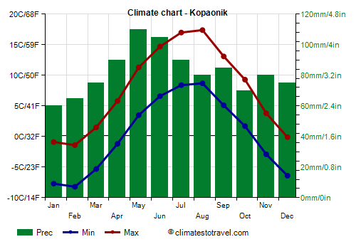
Kopaonik - Climate data
The
average temperature of the coldest month (January) is of -4.1 °C (24.6 °F), that of the warmest month (August) is of 13.8 °C (56.8 °F). Here are the average temperatures.
Kopaonik - Average temperatures (1991-2018) | Month | Min (°C) | Max (°C) | Mean (°C) | Min (°F) | Max (°F) | Mean (°F) |
|---|
| January | -7.4 | -0.8 | -4.1 | 19 | 31 | 24.6 |
|---|
| February | -7.4 | -0.8 | -4.1 | 19 | 31 | 24.6 |
|---|
| March | -5 | 1.8 | -1.6 | 23 | 35 | 29.1 |
|---|
| April | -0.8 | 6.3 | 2.7 | 31 | 43 | 36.9 |
|---|
| May | 3.7 | 11.6 | 7.6 | 39 | 53 | 45.7 |
|---|
| June | 7.1 | 15.4 | 11.3 | 45 | 60 | 52.3 |
|---|
| July | 8.9 | 17.6 | 13.3 | 48 | 64 | 55.9 |
|---|
| August | 9.3 | 18.2 | 13.8 | 49 | 65 | 56.8 |
|---|
| September | 5.5 | 13.2 | 9.3 | 42 | 56 | 48.8 |
|---|
| October | 1.9 | 9.4 | 5.6 | 35 | 49 | 42.2 |
|---|
| November | -2 | 4.7 | 1.3 | 28 | 40 | 34.4 |
|---|
| December | -6.2 | 0.2 | -3 | 21 | 32 | 26.6 |
|---|
| Year | 0.7 | 8.1 | 4.4 | 33.2 | 46.6 | 40 |
|---|
amounts to 1025 millimeters (40.4 inches) per year: it is therefore quite abundant. It ranges from 65 mm (2.6 in) in the driest months (January, February) to 120 mm (4.7 in) in the wettest one (May). Here is the average precipitation.
Kopaonik - Average precipitation| Month | Millimeters | Inches | Days |
|---|
| January | 65 | 2.6 | 11 |
|---|
| February | 65 | 2.6 | 12 |
|---|
| March | 90 | 3.5 | 13 |
|---|
| April | 95 | 3.7 | 12 |
|---|
| May | 120 | 4.7 | 13 |
|---|
| June | 105 | 4.1 | 11 |
|---|
| July | 95 | 3.7 | 10 |
|---|
| August | 75 | 3 | 8 |
|---|
| September | 90 | 3.5 | 9 |
|---|
| October | 80 | 3.1 | 9 |
|---|
| November | 75 | 3 | 10 |
|---|
| December | 75 | 3 | 12 |
|---|
| Year | 1025 | 40.4 | 131 |
|---|
There are on average around 1960
sunshine hours per year. Here are the average hours of sunshine per day.
Kopaonik - Sunshine hours| Month | Average | Total |
|---|
January | 3 | 95 | February | 3.5 | 95 | March | 4 | 130 | April | 5 | 155 | May | 6 | 190 | June | 7.5 | 230 | July | 8.5 | 270 | August | 8.5 | 265 | September | 6 | 185 | October | 5 | 160 | November | 3.5 | 110 | December | 3 | 85 | Year | 5.4 | 1960 |
Kopaonik - Weather by month
Based on the period 1991-2018
January, the coldest month of the year, is generally a very cold month. The average temperature is of -4.1 °C (25 °F), with a minimum of -7.4 °C (18.6 °F) and a maximum of -0.8 °C (30.5 °F).

On the coldest nights of the month, the temperature usually drops to around -17 °C (2 °F). However, it dropped to -24.8 °C (-12.6 °F) in January 2017.

On the warmest days of the month, the temperature usually reaches around 8 °C (46 °F). However, it reached 12.7 °C (54.9 °F) in January 2001.

Precipitation amounts to 65 mm (2.6 in), distributed over 11 days.
The day lasts on average 9 hours and 25 minutes.

There are on average 3 hours of sunshine per day. So, the sun shines 32% of the time.
The average humidity is 81%. Hence, the air is normally humid.
February is generally a very cold month. The average temperature is of -4.1 °C (25 °F), with a minimum of -7.4 °C (18.7 °F) and a maximum of -0.8 °C (30.6 °F).
On the coldest nights of the month, the temperature usually drops to around -16 °C (3.5 °F). However, it dropped to -24.2 °C (-11.6 °F) in February 2004.
On the warmest days of the month, the temperature usually reaches around 7.5 °C (45.5 °F). However, it reached 12.6 °C (54.7 °F) in February 1993.
Precipitation amounts to 65 mm (2.6 in), distributed over 12 days.
The day lasts on average 10 hours and 30 minutes.
There are on average 3.5 hours of sunshine per day. So, the sun shines 31% of the time.
The average humidity is 83%. Hence, the air is normally humid.
March is generally a very cold month. The average temperature is of -1.6 °C (29 °F), with a minimum of -5 °C (22.9 °F) and a maximum of 1.8 °C (35.3 °F).
On the coldest nights, which normally occur at the beginning of the month, the temperature usually drops to around -14 °C (7 °F). However, it dropped to -23.4 °C (-10.1 °F) in March 2005.
On the warmest days, which normally occur at the end of the month, the temperature usually reaches around 10.5 °C (50.5 °F). However, it reached 16.8 °C (62.2 °F) in March 2001.
Precipitation amounts to 90 mm (3.5 in), distributed over 13 days.
The day lasts on average 12 hours and 0 minutes.
There are on average 4 hours of sunshine per day. So, the sun shines 35% of the time.
The average humidity is 82%. Hence, the air is normally humid.
April is generally a cold month. The average temperature is of 2.7 °C (37 °F), with a minimum of -0.8 °C (30.5 °F) and a maximum of 6.3 °C (43.4 °F).
On the coldest nights, which normally occur at the beginning of the month, the temperature usually drops to around -8 °C (17.5 °F). However, it dropped to -15.2 °C (4.6 °F) in April 2003.
On the warmest days, which normally occur at the end of the month, the temperature usually reaches around 14.5 °C (58 °F). However, it reached 19.5 °C (67.1 °F) in April 2013.
Precipitation amounts to 95 mm (3.7 in), distributed over 12 days.
The day lasts on average 13 hours and 30 minutes.
There are on average 5 hours of sunshine per day. So, the sun shines 38% of the time.
The average humidity is 80%. Hence, the air is normally humid.
May is generally a quite mild month. The average temperature is of 7.6 °C (46 °F), with a minimum of 3.7 °C (38.6 °F) and a maximum of 11.6 °C (52.9 °F).
On the coldest nights, which normally occur at the beginning of the month, the temperature usually drops to around -2 °C (28 °F). However, it dropped to -5.3 °C (22.5 °F) in May 2001.
On the warmest days, which normally occur at the end of the month, the temperature usually reaches around 18.5 °C (65.5 °F). However, it reached 23.7 °C (74.7 °F) in May 2015.
Precipitation amounts to 120 mm (4.7 in), distributed over 13 days.
The day lasts on average 14 hours and 40 minutes. So the days are long.
There are on average 6 hours of sunshine per day. So, the sun shines 42% of the time.
The average humidity is 79%. Hence, the air is normally humid.
June is generally a mild month. The average temperature is of 11.3 °C (52 °F), with a minimum of 7.1 °C (44.8 °F) and a maximum of 15.4 °C (59.8 °F).
On the coldest nights, which normally occur at the beginning of the month, the temperature usually drops to around 1 °C (34 °F). However, it dropped to -2.2 °C (28 °F) in June 2005.
On the warmest days, which normally occur at the end of the month, the temperature usually reaches around 22.5 °C (72 °F). However, it reached 25.6 °C (78.1 °F) in June 2007.
Precipitation amounts to 105 mm (4.1 in), distributed over 11 days.
The day lasts on average 15 hours and 20 minutes. So the days are long. June 21, the summer solstice, is the longest day of the year in the Northern Hemisphere.
There are on average 7.5 hours of sunshine per day. So, the sun shines 50% of the time.
The average humidity is 79%. Hence, the air is normally humid.
July is generally a mild month. The average temperature is of 13.3 °C (56 °F), with a minimum of 8.9 °C (48 °F) and a maximum of 17.6 °C (63.7 °F).
On the coldest nights of the month, the temperature usually drops to around 4 °C (39 °F). However, it dropped to 0.1 °C (32.2 °F) in July 2000.
On the warmest days of the month, the temperature usually reaches around 24 °C (75 °F). However, it reached 30 °C (86 °F) in July 2007.
Precipitation amounts to 95 mm (3.7 in), distributed over 10 days.
The day lasts on average 15 hours and 0 minutes. So the days are long.
There are on average 8.5 hours of sunshine per day. So, the sun shines 58% of the time.
The average humidity is 75%. Hence, the air is normally humid.
August, the warmest month of the year, is generally a mild month. The average temperature is of 13.8 °C (57 °F), with a minimum of 9.3 °C (48.8 °F) and a maximum of 18.2 °C (64.7 °F).
On the coldest nights of the month, the temperature usually drops to around 3.5 °C (38 °F). However, it dropped to -0.9 °C (30.4 °F) in August 2005.
On the warmest days of the month, the temperature usually reaches around 24.5 °C (76 °F). However, it reached 29.2 °C (84.6 °F) in August 2007.
Precipitation amounts to 75 mm (3 in), distributed over 8 days.
The day lasts on average 13 hours and 55 minutes.
There are on average 8.5 hours of sunshine per day. So, the sun shines 62% of the time.
The average humidity is 74%. Hence, the air is normally humid.
September is generally a mild month. The average temperature is of 9.3 °C (49 °F), with a minimum of 5.5 °C (41.9 °F) and a maximum of 13.2 °C (55.8 °F).
On the coldest nights, which normally occur at the end of the month, the temperature usually drops to around -1 °C (30.5 °F). However, it dropped to -4.2 °C (24.4 °F) in September 1995.
On the warmest days, which normally occur at the beginning of the month, the temperature usually reaches around 20 °C (68 °F). However, it reached 26.5 °C (79.7 °F) in September 2015.
Precipitation amounts to 90 mm (3.5 in), distributed over 9 days.
The day lasts on average 12 hours and 25 minutes.
There are on average 6 hours of sunshine per day. So, the sun shines 49% of the time.
The average humidity is 80%. Hence, the air is normally humid.
October is generally a quite cold month. The average temperature is of 5.6 °C (42 °F), with a minimum of 1.9 °C (35.5 °F) and a maximum of 9.4 °C (48.9 °F).
On the coldest nights, which normally occur at the end of the month, the temperature usually drops to around -6.5 °C (20.5 °F). However, it dropped to -12.5 °C (9.5 °F) in October 1991.
On the warmest days, which normally occur at the beginning of the month, the temperature usually reaches around 17.5 °C (63 °F). However, it reached 22.4 °C (72.3 °F) in October 2012.
Precipitation amounts to 80 mm (3.1 in), distributed over 9 days.
The day lasts on average 11 hours and 0 minutes.
There are on average 5 hours of sunshine per day. So, the sun shines 46% of the time.
The average humidity is 80%. Hence, the air is normally humid.
November is generally a cold month. The average temperature is of 1.4 °C (34 °F), with a minimum of -2 °C (28.4 °F) and a maximum of 4.7 °C (40.4 °F).
On the coldest nights, which normally occur at the end of the month, the temperature usually drops to around -11 °C (12 °F). However, it dropped to -15.6 °C (3.9 °F) in November 1995.
On the warmest days, which normally occur at the beginning of the month, the temperature usually reaches around 13.5 °C (56 °F). However, it reached 21.4 °C (70.5 °F) in November 2004.
Precipitation amounts to 75 mm (3 in), distributed over 10 days.
The day lasts on average 9 hours and 40 minutes.
There are on average 3.5 hours of sunshine per day. So, the sun shines 38% of the time.
The average humidity is 81%. Hence, the air is normally humid.
December is generally a very cold month. The average temperature is of -3.0 °C (27 °F), with a minimum of -6.2 °C (20.8 °F) and a maximum of 0.2 °C (32.4 °F).
On the coldest nights of the month, the temperature usually drops to around -15.5 °C (4.5 °F). However, it dropped to -20.4 °C (-4.7 °F) in December 1991.
On the warmest days of the month, the temperature usually reaches around 8 °C (46.5 °F). However, it reached 12.9 °C (55.2 °F) in December 2000.
Precipitation amounts to 75 mm (3 in), distributed over 12 days.
The day lasts on average 9 hours and 0 minutes. December 21, the winter solstice, is the shortest day of the year in the Northern Hemisphere.
There are on average 3 hours of sunshine per day. So, the sun shines 31% of the time.
The average humidity is 84%. Hence, the air is normally humid.