Select units of measurement for the temperature and rainfall tables (metric or imperial).
Average weather, temperature, rainfall, sunshine hours
Novaya Zemlya has a
polar climate, with temperatures below freezing most of the year, and slightly above freezing in summer.
Novaya Zemlya ("New Land" in Russian) is located in the north of Russia, between 70 and 77 degrees north latitude, between the Barents Sea to the west and the Kara Sea to the east. We are in the easternmost area of Europe, given that the longitude is even greater than the Ural Mountains, which separate European Russia from Siberia, and of which Novaya Zemlya is the extension from a geological point of view.
The archipelago consists of two major islands, Severnyj and Yužnyj (North Island and South Island), separated by the Matochkin Strait, as well as numerous smaller islands. The total area is 82,600 square kilometers (32,000 square miles). Administratively it belongs to the Arkhangelsk Oblast.
The
wind blows often and with considerable force, although it decreases somewhat in summer.
The
sea is almost always free of ice on the west coast, where the last branch of the Gulf Stream reaches, except in the coldest winters. On the east coast, on the other hand, sea ice retreats only from July to October or November. However, the extent of the ice varies from year to year.
While the southern island is mostly flat and free of snow in summer (when mosses and lichens grow there), on Severny Island, the interior areas are occupied by
hills and mountains, covered by perennial ice. The highest point is
Mount Kruzenshtern, 1,547 meters (5,075 ft) high.
The main settlement,
Belushya Guba, located on the southern island (Yuzhnyj), has about 2,000 inhabitants. Here, the
sun stays above the horizon (midnight sun) from May 10 to August 1st, while it stays below the horizon (polar night) from November 18 to January 23.

About 90 km (55 mi) further north, but still in the mildest part of the archipelago, is the
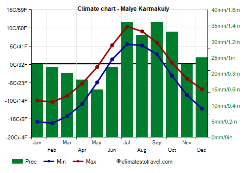
Malye Karmakuly station.
The coldest time of year is from January to March. In February, the coldest month, the
average temperature is about -13 °C (8.5 °F), while on the northern island it is a few degrees lower.
During the most intense
cold waves, the temperature can drop below -30 °C (-22 °F). The coldest record is -39 °C (-38 °F), set in February and March 1979.
In
summer, the temperature in Malye Karmakuly exceeds freezing for four months, and the average in July, the warmest month, is 8 °C (46.5 °F). In the central-northern part of Novaya Zemlya, the summer is colder, so much so that the temperature barely exceeds freezing.
From June to August, there can be short periods of very mild or warm weather, when the temperature can exceed 20 °C (68 °F). The warmest record in Malye Karmakuly is 28.3 °C (82.9 °F), set in July 1989. However, on the northern island these temperatures are not reached, and at most they reach 10/12 °C (50/54 °F) in the most sheltered areas.
Here are the average temperatures.
Malye Karmakuly - Average temperatures (1991-2020) |
| Month | Min | Max | Mean |
|---|
| January | -15.7 | -9.9 | -12.8 |
|---|
| February | -16.1 | -10.3 | -13.2 |
|---|
| March | -14.2 | -8.6 | -11.4 |
|---|
| April | -10.8 | -5.2 | -8 |
|---|
| May | -4.9 | -0.7 | -2.8 |
|---|
| June | 1.4 | 5.3 | 3.4 |
|---|
| July | 5.6 | 10.4 | 8 |
|---|
| August | 5.2 | 9.1 | 7.2 |
|---|
| September | 2.8 | 6 | 4.4 |
|---|
| October | -3.1 | 0.5 | -1.3 |
|---|
| November | -8.4 | -3.9 | -6.2 |
|---|
| December | -12.1 | -6.8 | -9.4 |
|---|
| Year | -5.8 | -1.1 | -3.45 |
|---|
is low, around 310 mm (12 inches) per year. It falls as snow for most of the year, while from June to September it usually falls as rain, at least in Malye Karmakuly and the south.
Here are the average precipitation.
Malye Karmakuly - Average precipitation| Month | Days |
|---|
| January | 27 | 7 |
|---|
| February | 23 | 7 |
|---|
| March | 20 | 6 |
|---|
| April | 18 | 6 |
|---|
| May | 14 | 5 |
|---|
| June | 19 | 5 |
|---|
| July | 40 | 8 |
|---|
| August | 29 | 8 |
|---|
| September | 36 | 10 |
|---|
| October | 34 | 10 |
|---|
| November | 23 | 7 |
|---|
| December | 28 | 8 |
|---|
| Year | 310 | 87 |
|---|
The
sun shines rarely, around 1,200 hours per year, with a maximum from April to July. Here are the average hours of sunshine per day.
Malye Karmakuly - Sunshine hours| Month | Average | Total |
|---|
| January | 0 | 0 |
|---|
| February | 1 | 25 |
|---|
| March | 3.5 | 105 |
|---|
| April | 7 | 215 |
|---|
| May | 6 | 190 |
|---|
| June | 6 | 175 |
|---|
| July | 7.5 | 230 |
|---|
| August | 4.5 | 145 |
|---|
| September | 2.5 | 75 |
|---|
| October | 1.5 | 40 |
|---|
| November | 0 | 5 |
|---|
| December | 0 | 0 |
|---|
| Year | 3.3 | 1195 |
|---|