Select units of measurement for the temperature and rainfall tables (metric or imperial).
Average weather, temperature, rainfall, sunshine hours

Zahlé's climate is
continentalized Mediterranean, with mild, rainy winters and hot, sunny summers.
Zahlé is a city of 100,000 inhabitants, the capital of the Beqaa governorate, located in eastern Lebanon, in the Bekaa Valley, at 950 meters (3,100 feet) above sea level, at almost 34 degrees north latitude.
To the west are the
mountains of the Lebanon chain, which in this area reach 2,628 meters (8,622 ft) in Mount Sannine.
The mountains isolate the Bekaa Valley from the sea, making the climate more continental. Altitude also has its influence on the climate.
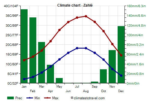
Precipitation is not abundant, since it amounts to 650 millimeters (25.5 inches) per year, however, it is concentrated from November to March, a period during which it can be abundant. In summer, however, it almost never rains.
Winter, from December to February, is quite mild, with an average January temperature of around 7 °C (44.5 °F).
Fog can form during periods of stable weather.
There are very mild periods, during which the temperature can reach 20 °C (68 °F) even in the middle of winter.
However, there can also be
cold periods, during which the temperature drops to around freezing, and
snow can also fall. Snowfall can sometimes be heavy.
During the most intense cold spells, the temperature can drop to -10 °C (14 °F).
Summer, from June to September, is very hot and sunny, despite the altitude. However, humidity is not high, and at night the temperature drops considerably. The average for August, the hottest month, is 26.5 °C (79.5 °F).
The
khamsin, the wind that blows from the deserts of Egypt, can bring the temperature above 40 °C (104 °F).
In 2020, the temperature reached 45.4 °C (13.7 °F) in late July and 44.3 °C (111.7 °F) in early September.
Zahlé - Climate data
In Zahlé, the
average temperature of the coldest month (January) is of
7.1 °C, that of the warmest month (August) is of
26.4 °C. Here are the average temperatures.
Zahlé - Average temperatures (1995-2020) |
| Month | Min | Max | Mean |
|---|
| January | 2.2 | 12 | 7.1 |
|---|
| February | 3.3 | 13.8 | 8.6 |
|---|
| March | 5.6 | 17 | 11.3 |
|---|
| April | 8.7 | 21.8 | 15.2 |
|---|
| May | 12.4 | 27.6 | 20 |
|---|
| June | 15.8 | 31.7 | 23.8 |
|---|
| July | 18.2 | 34 | 26.1 |
|---|
| August | 18.2 | 34.7 | 26.4 |
|---|
| September | 15.8 | 31.8 | 23.8 |
|---|
| October | 12.3 | 27 | 19.6 |
|---|
| November | 7.4 | 20.3 | 13.8 |
|---|
| December | 4 | 14.5 | 9.2 |
|---|
| Year | 10.4 | 23.9 | 17.1 |
|---|
amounts to
640 millimeters per year: so, it is at an intermediate level. It ranges from
0.1 millimeters in the driest month (June) to
153 millimeters in the wettest one (January). Here is the average precipitation.
Zahlé - Average precipitation| Month | Days |
|---|
| January | 153 | 12 |
|---|
| February | 136 | 10 |
|---|
| March | 85 | 9 |
|---|
| April | 38 | 5 |
|---|
| May | 11 | 2 |
|---|
| June | 0 | 0 |
|---|
| July | 0 | 0 |
|---|
| August | 0 | 0 |
|---|
| September | 3 | 1 |
|---|
| October | 29 | 4 |
|---|
| November | 68 | 7 |
|---|
| December | 118 | 10 |
|---|
| Year | 640 | 61 |
|---|