Select units of measurement for the temperature and rainfall tables (metric or imperial).
Average weather, temperature, rainfall, sunshine hours
In Hokkaido there is a
semi-continental climate, with cold, snowy winters, and very mild or relatively warm, rainy summers.
Like the rest of Japan, the island is affected by the
monsoon circulation: in winter, cold currents from the northwest prevail, while in summer, warm and humid currents of tropical origin prevail, although here up north they arrive in a weaker state.
Hokkaido is the northernmost of Japan's main islands, and is located southeast of Siberia, between 41 and 45 degrees north latitude. To the north, in the Sea of Okhotsk, flows a cold sea current, called
Oya-Shio, which in winter carries floating ice to the north-east exposed coast.
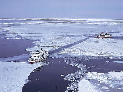
In the interior, there are also
volcanic mountains, including the Ishikari mountains. The highest peak is Mount Asahi, inside the Daisetsuzan National Park, at 2,291 meters (7,516 feet).
There are also
resorts for winter sports. Skiing is generally possible from December to April.
In
winter, the average temperature in January is below freezing everywhere, and is about -2 °C (28.5 °F) in the southern tip, it generally fluctuates between -4 and -6 °C (21 and 25 °F) on the coasts, while it ranges from -6 to -11 °C (12 to 21 °F) in the inland areas.
During
cold waves, temperatures can drop to -15 °C (5 °F) at the southern tip, -25 °C (-13 °F) on the northeast coast, and -30 °C (-22 °F) in the interior.
Summer is decidedly milder than in the rest of Japan, where sweltering heat dominates. The average for August is generally 21/22 °C (70/71.5 °F °F), but on the cooler east coast, it ranges from 17 to 20 °C (62.5 to 68 °F).
However, there can sometimes be
very hot periods, during which the temperature can reach around 35 °C (95 °F).
Precipitation ranges from about 850 millimeters (33.5 inches) per year on the coast of the Sea of Okhotsk (the lowest level in all of Japan), to 1,600 mm (63 in) on the western side of the mountains. In most of the island, however, it fluctuates between 1,000 and 1,150 mm (39 and 45 in) per year. The wettest seasons are generally summer and autumn, the driest is spring.
Snowfall is very heavy, at a level among the highest in the world. The snowiest area is the western one, because the winds from Siberia load up with moisture passing over a relatively mild sea, the Sea of Japan. In Wakkanai, on the northwest coast, as much as six and a half meters (260 inches) of snow fall per year, while in Sapporo, the main city, near the west coast, 4 meters and 80 cm (189 in) fall. On the western side of the mountains, up to 11 meters (36 feet) of snow fall per year.
Abashiri
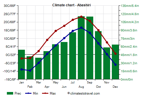
In
Abashiri, on the northeastern coast, where in February a "drift ice festival" is held, the average temperature ranges from -6 °C (21 °F) in February to 20 °C (68 °F) in August. So, not only is the winter cold, but the summer is not very warm.
Abashiri - Average temperatures (1991-2020) |
| Month | Min | Max | Mean |
|---|
| January | -8.9 | -2.2 | -5.6 |
|---|
| February | -9.6 | -2 | -5.8 |
|---|
| March | -4.9 | 2.3 | -1.3 |
|---|
| April | 0.6 | 9.1 | 4.8 |
|---|
| May | 5.8 | 14.6 | 10.2 |
|---|
| June | 10.2 | 17.7 | 14 |
|---|
| July | 14.6 | 21.4 | 18 |
|---|
| August | 16.6 | 23.3 | 20 |
|---|
| September | 13.4 | 20.7 | 17 |
|---|
| October | 7 | 15 | 11 |
|---|
| November | 0.4 | 7.6 | 4 |
|---|
| December | -6 | 0.7 | -2.6 |
|---|
| Year | 3.3 | 10.8 | 7 |
|---|
Abashiri is one of the least rainy cities in Japan, in fact it receives 845 millimeters (33 inches) per year, because the cold current inhibits the formation of clouds that can generate rain or snow. In return,
fog can form, especially in summer, when the cold current meets warm air masses coming from the south.
However, as high as 380 cm (150 in) of snow fall per year on average, since the temperatures are low for a long period, so it can snow from November to April.
Abashiri - Average precipitation| Month | Days |
|---|
| January | 54 | 13 |
|---|
| February | 42 | 9 |
|---|
| March | 39 | 9 |
|---|
| April | 51 | 8 |
|---|
| May | 64 | 10 |
|---|
| June | 68 | 9 |
|---|
| July | 86 | 9 |
|---|
| August | 115 | 10 |
|---|
| September | 115 | 10 |
|---|
| October | 88 | 10 |
|---|
| November | 58 | 10 |
|---|
| December | 64 | 12 |
|---|
| Year | 845 | 119 |
|---|
On the northeastern coast, the sea is very cold in winter, in fact it is close to freezing point. Remember that, being salty, the sea freezes at about -2 °C (28.5 °F).
Abashiri - Sea temperature| Month |
|---|
| January | 0.5 |
|---|
| February | -0.5 |
|---|
| March | -0.5 |
|---|
| April | 0.5 |
|---|
| May | 3 |
|---|
| June | 8 |
|---|
| July | 12.5 |
|---|
| August | 16 |
|---|
| September | 15 |
|---|
| October | 11.5 |
|---|
| November | 7"> |
|---|
| December | 3 |
|---|
| Year | 6.3 |
|---|
Sapporo
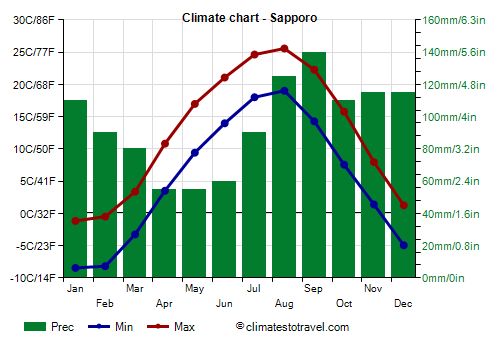
In
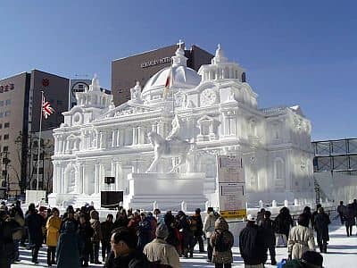
Sapporo, which as mentioned is located near the west coast, and which hosted the 1972 Winter Olympic Games, the average temperature in January is -5 degrees Celsius (23 °F). The temperature remains below freezing (0 °C or 32 °F) from December to March, and there are 130 days with snowfall in a normal cold season. In February, the
Sapporo Snow Festival is held, attracting millions of visitors to admire statues and sculptures made of ice.
Sapporo - Average temperatures (1991-2020) |
| Month | Min | Max | Mean |
|---|
| January | -8.4 | -1.2 | -4.8 |
|---|
| February | -8.2 | -0.5 | -4.3 |
|---|
| March | -3.2 | 3.4 | 0.1 |
|---|
| April | 3.5 | 10.8 | 7.2 |
|---|
| May | 9.4 | 17 | 13.2 |
|---|
| June | 14 | 21.1 | 17.5 |
|---|
| July | 18 | 24.6 | 21.3 |
|---|
| August | 19 | 25.6 | 22.3 |
|---|
| September | 14.3 | 22.3 | 18.3 |
|---|
| October | 7.6 | 15.8 | 11.7 |
|---|
| November | 1.4 | 8 | 4.7 |
|---|
| December | -4.9 | 1.3 | -1.8 |
|---|
| Year | 5.3 | 12.4 | 8.8 |
|---|
In Sapporo, 1,150 mm (45 in) of rain or snow fall per year; the (relatively) least rainy season is spring. In winter, frequent and abundant snowfalls occur.
Sapporo - Average precipitation| Month | Days |
|---|
| January | 110 | 22 |
|---|
| February | 90 | 19 |
|---|
| March | 80 | 18 |
|---|
| April | 55 | 12 |
|---|
| May | 55 | 10 |
|---|
| June | 60 | 9 |
|---|
| July | 90 | 9 |
|---|
| August | 125 | 10 |
|---|
| September | 140 | 12 |
|---|
| October | 110 | 14 |
|---|
| November | 115 | 18 |
|---|
| December | 115 | 20 |
|---|
| Year | 1145 | 175 |
|---|
As mentioned, the Sea of Japan is not as cold as the Sea of Okhotsk. In summer, it is still quite cool, though it reaches 21 °C (70 °F) in August.
Sapporo - Sea temperature| Month |
|---|
| January | 5.5 |
|---|
| February | 4 |
|---|
| March | 4.5 |
|---|
| April | 6 |
|---|
| May | 9.5 |
|---|
| June | 13.5 |
|---|
| July | 18 |
|---|
| August | 21 |
|---|
| September | 20.5 |
|---|
| October | 16.5 |
|---|
| November | 12"> |
|---|
| December | 8.5 |
|---|
| Year | 11.7 |
|---|
In the interior of Hokkaido, winter is even colder, and in the eastern part (see Shimukappu, Obihiro, Rikubetsu), the January average reaches -10/-11 °C (12/14 °F).
Asahikawa
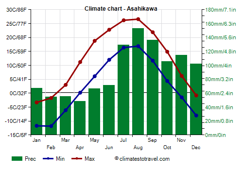
In Asahikawa, in the central area, the average January temperature is -7 °C (19.5 °F), while in summer, due to the distance from the sea, temperatures are a little higher. Here are the average temperatures.
Asahikawa - Average temperatures (1991-2020) |
| Month | Min | Max | Mean |
|---|
| January | -11.7 | -3.3 | -7.5 |
|---|
| February | -11.8 | -1.7 | -6.8 |
|---|
| March | -6.1 | 3 | -1.5 |
|---|
| April | 0.2 | 11.2 | 5.7 |
|---|
| May | 6.1 | 18.8 | 12.4 |
|---|
| June | 12 | 22.8 | 17.4 |
|---|
| July | 16.4 | 26.2 | 21.3 |
|---|
| August | 16.9 | 26.6 | 21.8 |
|---|
| September | 11.7 | 21.9 | 16.8 |
|---|
| October | 4.4 | 14.9 | 9.6 |
|---|
| November | -1.5 | 6.2 | 2.4 |
|---|
| December | -8 | -0.8 | -4.4 |
|---|
| Year | 2.5 | 12.2 | 7.3 |
|---|
Precipitation amounts to 1,100 mm (43 in), with more than 100 mm (4 in) per month from July to December.
Asahikawa - Average precipitation| Month | Days |
|---|
| January | 67 | 17 |
|---|
| February | 55 | 14 |
|---|
| March | 55 | 13 |
|---|
| April | 48 | 10 |
|---|
| May | 67 | 10 |
|---|
| June | 71 | 9 |
|---|
| July | 130 | 10 |
|---|
| August | 153 | 10 |
|---|
| September | 136 | 12 |
|---|
| October | 106 | 14 |
|---|
| November | 114 | 18 |
|---|
| December | 102 | 21 |
|---|
| Year | 1105 | 159 |
|---|
Best Time
The best time to visit Hokkaido is
mid-May to mid-September, keeping in mind that it can get cold at night and in the mountains even during this period.
July and August are the months when it is most unlikely to get cold, however, especially from mid-July to mid-August, there can be hot and muggy periods, in addition, sometimes a typhoon can pass.
In fact, from June to October (but especially from August to early October), Hokkaido may also be affected by
typhoons, the tropical cyclones of the western Pacific, which mostly affect the southern part of Japan, and arrive here in the north more rarely and generally weakened. The fact remains that they can bring strong winds and abundant rains.
The
cherry blossoming (Sakura) in Hokkaido takes place during the month of May, with some variability depending on the year.