Iceland has a
subarctic climate, cold, windy and cloudy most of the year. Of course, it's a cold country because of the high latitude, and it can receive cold winds from the North Pole, but it's also tempered by the ocean, as well as by the mild Gulf Stream that flows in it.
The result is a
perpetually unstable climate, with sudden changes in weather and temperature, but with a limited temperature range, both between day and night and between winter and summer. Calm and sunny periods are rare. The northern coastal area is colder than the southern one because it is not reached by the Gulf Stream.
Precipitation (rain or snow) is more abundant on the southern side, where it exceeds 1,300 millimeters (50 inches) per year, and reaches up to 2,500 millimeters (98 in) in the most exposed areas (see Vík í Mýrdal), while it's much more scarce on the north coast and on the north side of the inner plateau, so much so that it descends below 500 mm (20 in) per year, although it is well distributed throughout the year.
Along the west coast, the amount of precipitation is at an intermediate level; for instance, Reykjavik, receives about 850 mm (34 in) of rain or snow each year. On the southern slopes of the highest mountains, precipitation, which almost always takes the form of snow, can exceed 4,000 mm (155 in) per year.
The amount of
sunshine in Iceland is not good, but it is generally passable in late spring and summer, also because of the very long days, while it is decidedly low in November in January, when the sun hardly ever shows up (also because the days are very short). Reykjavik gets just 1,300 hours of sunshine a year, and in Akureyri only 1,000 (a figure that makes it one of the least sunny cities in the world).
The climate in detail
The seasons
Winter in Iceland is not so cold, in fact, the average temperature in plains and coasts is around the freezing point. This means that the temperatures can exceed 0 °C (32 °F) quite often even in winter, and rain can fall instead of snow.
Along the northern coast, winter is colder by a few degrees, and sometimes the sea can freeze inside fjords.
In inland areas, winter is even colder, especially with increasing altitude.
Snowfalls are plentiful along the southern slopes, while they are frequent but less abundant elsewhere.
Winter is in any case
very long, and the temperature increases very slowly over the months. In April, daytime temperatures are still around 6 °C (43 °F) in Reykjavik. Across Iceland, it can snow from October to May; along the northern coasts, sudden snow showers may occur even in June and September, while in inland areas, this can happen even in midsummer because of the altitude.
Cold spells in Iceland are short-lived. During winter, cold air masses from Greenland can lower the temperatures to around -10/-15 °C (5/14/15 °F), however, after a while, the mild winds from the south begin to blow again.
Cold records are not so low, at least for the latitude, in fact they are around -20 °C (-4 °F) along the coast, while they go down to -30 °C (-22 °F) in inland areas.
 Husavik
Summer
Husavik
Summer is very cool throughout Iceland. In Reykjavík, during the warmest months, July and August, lows are around 9 °C (48 °F) and highs around 14/15 °C (57/59 °F), while on the north coast they are around 10/12 °C (50/54 °F).
On the other hand, the days are very long.
In Iceland, it practically never gets hot: the temperature rises rarely and for short periods above 20 °C (68 °F). The highest records along the coast are around 26 °C (79 °F), while in some sheltered inland areas they are around 28 °C (82 °F).
The coasts
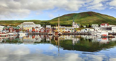
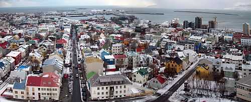
Along the coasts we find the main cities of Iceland. However, Reykjavík is the only city of some importance.
Reykjavík
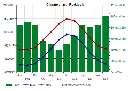
![]() Climate chart - Reykjavik
Climate chart - Reykjavik
In the capital,
Reykjavík, located on the south-west coast of the island, the average temperature ranges from 0.5 °C (33 °F) in January and February to 12 °C (53.5 °F) in July.
The
sea in Iceland is cold throughout the year: the water temperature near Reykjavik ranges from 5 °C (41 °F) in February to 10 °C (50 °F) in July and August, so it's preferable to bathe in thermal pools...
 Reykjavìk
On the southern coast (see
Vík í Mýrdal and the
Vestmann Islands), the sea temperature reaches up to 12 °C (53.5 °F) in August.
Akureyri
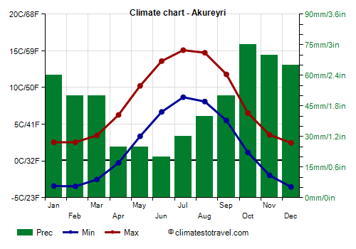
![]() Climate chart - Akureyri
Akureyri
Climate chart - Akureyri
Akureyri, the second largest city of the country, is located on the north coast, although within a fjord. Here, the monthly average temperature ranges from -0.5 °C (31 °F) in January and February to 12 °C (53 °F) in July.
Being sheltered from the south wind, Akureyri is located in the least rainy area of Iceland; in fact, precipitation amounts to 550 mm (21.5 in) per year.
On the north coast, the sea is colder, so much so that its temperature only reaches 8 °C (46.5 °F) in August.
 Grimsey
On the islet of
Grimsey, north of Akureyri, and to a lesser extent on the Vestmann to the south-west, the daytime temperatures in summer are lower. This shows that when you go on
boat trips, you can easily encounter cold and windy weather even in summer.
Inland areas
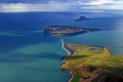
Iceland is the land of ice, fire and deserts. In the interior, there are vast
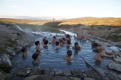
glaciers, from which ice tongues descend towards the plains, while geothermal activity causes the presence of geysers and hot water springs, where people can bathe even if there is snow around; on the other hand, underground volcanic activity may cause sudden melting of glaciers, with the risk of flooding. It's worth noting the almost total absence of trees, as well as the presence of sandy soils in inland areas, where strong winds can cause dust storms.
In inland areas, there are
plateaus and mountains, where the temperature naturally decreases with altitude. Because of the cold summers and the heavy snowfalls, snow only melts at low altitude, so the snowline is low, around 700 meters (2,300 feet) above sea level. However, Iceland's glaciers are shrinking due to global warming.
The vast
Vatnajökull glacier is a plateau about 1,500 meters (4,900 feet) high, and about 380 meters (1,250 ft) thick, below which there are several volcanoes. The highest peak in Iceland is
Hvannadalshnúkur, which is part of
Öræfajökull volcano, is located in the southern limit of
Vatnajökull, and is 2,110 high meters (6,920 ft) high.
Hveravellir
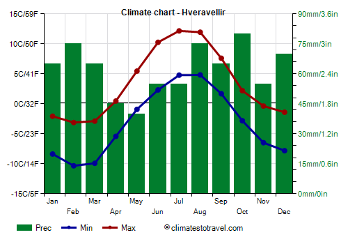
![]() Climate chart - Hveravellir
Climate chart - Hveravellir
For example, at the geothermal site of Hveravellir, located in the interior of the island, at an altitude of 640 meters (2,100 ft), the average daily temperature is below freezing for seven months of the year. Also, the temperature can drop to -15 °C (5 °F) or below from November to April.
 Hveravellir
Midnight sun
As in all the Nordic countries, the
length of the day has a significant effect on human activities: the months of late autumn and early winter are characterized by endless nights and very short days, when the sun remains very low above the horizon even at noon. In Reykjavík, at the winter solstice (21 December) the sun rises around 11:20 am and sets around 3:30 pm. By February, the days are longer than in the period from November to January, even though the temperature is not higher.
In summer, the days are long especially in June, when it doesn't get completely dark even at midnight, and in the north, around the
summer solstice (June 21) the sun does not set at all, since the extreme north of Iceland touches the Arctic Circle. On the small island of Grimsey, which is right on the Arctic Circle, at the summer solstice the sun remains just above the horizon at the moment when it is lower (which happens actually around 1 a.m.).
On the island of Iceland, the points closer to the Arctic Circle are the northeast (see
Raufarhöfn) and the northwest (see Ísafjörður), which are very close to the Arctic Circle. Thanks to the phenomenon called atmospheric refraction, the sun at midnight (or rather at one in the morning) can also be seen at Ísafjörður (from June 12 to July 1st), at Raufarhöfn (from June 8 to July 6), and in Húsavík (from June 13 to July 1st).
More to the south, already in Akureyri, the sun goes slightly below the horizon around 1 a.m. also at the solstice, while in Reykjavík, the sun goes below the horizon from midnight to 3 a.m, although it does not get completely dark.
The latter phenomenon, called
white nights, whereby the sun goes below the horizon but remains close enough, so much so that there are still sunset lights even at midnight, in Reykjavik lasts from April 27 to August 15.
Climate change
Iceland, like the rest of the world, is affected by global warming. As a result, the time of year when it snows gradually becomes shorter.
Cold waves also become less intense and less frequent.
The
glaciers are in retreat, and in recent decades, the extent has decreased from 10% of Iceland's surface to 8%. The smaller glaciers are at risk of disappearing, as has already happened to the Ok glacier (
Okjökull), which disappeared recently.
Glacier-fed
rivers can disappear, as happened to the Skeiðará River. Instead, the melting of the glaciers causes the
lakes that are nearby to enlarge while receiving more water from them.
The retreat of the glaciers causes the
uplift of the land, due to the decrease in the weight of the ice. As a result, the sea level drops, especially in the central-southern part of Iceland, where the land uplift reaches 3.5 centimeters (1.4 inches) per year. Since the 1930s, the earth has already risen by half a meter (20 in). This creates problems, for example ports become smaller and room for large ships is reduced. Furthermore, it is feared that the volcanoes and seismic faults that run through Iceland could be destabilized by this ground movement.
On the plus side, the higher temperature makes it possible to increase
agricultural production, and in particular the cultivation of cereals.
On the other hand, as far as
fishing is concerned, while some species of fish and crustaceans living in cold waters move north, other species coming from the south such as mackerel are becoming more and more frequent in Icelandic waters.
When to go
The best time to visit Iceland is
summer, from June to August. Spring is cold and it's quite similar to winter, with frequent snowfalls and frosts, but the days are longer than in autumn.
For
skiing and cross-country skiing, the month of March is preferable to the beginning of winter because the days are longer.
To observe the
northern lights (aurora borealis), since it must be night, the best time is from November to January, when the nights are longer.
What to pack
In
winter: bring warm clothes, a fleece, a down jacket, a hat, a scarf, gloves, a wind jacket, a raincoat or umbrella, hiking boots, swimsuit.
In
summer: bring a sweater, a shirt, a jacket, a hat, a scarf, hiking boots, rubber boots for hiking in the interior, a raincoat or umbrella, a windbreaker, swimsuit.
Back to topSee also the
temperatures month by month