![]() Climate chart - Temuco (Chile)
Climate chart - Temuco (Chile)
Temuco's climate is
mild oceanic. Winters (June to August) are mild and rainy, while summers (December to February) are pleasantly warm during the day and cool at night, and quite sunny. Although summer is the driest season, it can sometimes rain even in this season.
The city is located in south-central Chile, at 38 degrees south latitude and 70 kilometers (43 miles) away from the Pacific coast.
About 75 km (45 mi) to the east is Mount Llaima, one of the most active volcanoes in Chile, and 3,125 meters (10,253 feet) high.
Fog can form all year round, at night and in the early morning, but especially in winter.
In
winter, the rains are frequent and abundant. When the sky is clear, at night, the temperature can sometimes drop below freezing. However, snow is very rare, although occasionally a light snowfall can occur, such as in June 2017 and June 2018.
In
summer, temperatures are pleasant during the day, but nights are cool, and sometimes even cold. The cold records in this season are around freezing.
When the winds blow from the interior, there can be very hot days, although more rarely than in cities further north such as Chillán and Curicó. Furthermore, even in these cases, at night the temperature drops a lot.

Best Time
The
best time to visit Temuco goes from November to March, as it is the mildest and sunniest of the year. However, during the day it can sometimes be very hot, especially in January and February, moreover, at night it can get a bit cold even in this season. The sea is also cold for swimming.
Temuco - Climate data
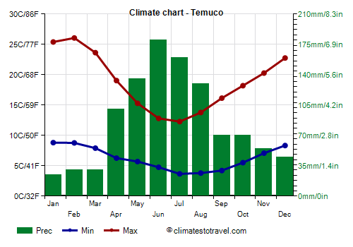
The
average temperature of the coldest month (July) is of 8.0 °C (46.4 °F), that of the warmest month (February) is of 17.4 °C (63.3 °F). Here are the average temperatures.
Temuco - Average temperatures (1991-2020) | Month | Min (°C) | Max (°C) | Mean (°C) | Min (°F) | Max (°F) | Mean (°F) |
|---|
| January | 8.8 | 25.4 | 17.1 | 48 | 78 | 62.8 |
|---|
| February | 8.8 | 26.1 | 17.4 | 48 | 79 | 63.3 |
|---|
| March | 7.9 | 23.6 | 15.8 | 46 | 75 | 60.4 |
|---|
| April | 6.3 | 19 | 12.7 | 43 | 66 | 54.8 |
|---|
| May | 5.7 | 15.3 | 10.5 | 42 | 60 | 50.9 |
|---|
| June | 4.8 | 12.8 | 8.8 | 41 | 55 | 47.8 |
|---|
| July | 3.7 | 12.3 | 8 | 39 | 54 | 46.4 |
|---|
| August | 3.8 | 13.8 | 8.8 | 39 | 57 | 47.8 |
|---|
| September | 4.2 | 16.2 | 10.2 | 40 | 61 | 50.3 |
|---|
| October | 5.5 | 18.2 | 11.9 | 42 | 65 | 53.3 |
|---|
| November | 7.1 | 20.3 | 13.7 | 45 | 69 | 56.6 |
|---|
| December | 8.3 | 22.8 | 15.6 | 47 | 73 | 60 |
|---|
| Year | 6.2 | 18.8 | 12.45 | 43.2 | 65.8 | 54.5 |
|---|
amounts to 1030 millimeters (40.6 inches) per year: it is therefore quite abundant. It ranges from 25 mm (1 in) in the driest month (January) to 180 mm (7.1 in) in the wettest one (June). Here is the average precipitation.
Temuco - Average precipitation| Month | Millimeters | Inches | Days |
|---|
| January | 25 | 1 | 4 |
|---|
| February | 30 | 1.2 | 4 |
|---|
| March | 30 | 1.2 | 6 |
|---|
| April | 100 | 3.9 | 9 |
|---|
| May | 135 | 5.3 | 14 |
|---|
| June | 180 | 7.1 | 16 |
|---|
| July | 160 | 6.3 | 15 |
|---|
| August | 130 | 5.1 | 14 |
|---|
| September | 70 | 2.8 | 11 |
|---|
| October | 70 | 2.8 | 10 |
|---|
| November | 55 | 2.2 | 7 |
|---|
| December | 45 | 1.8 | 6 |
|---|
| Year | 1030 | 40.6 | 116 |
|---|
There are on average around 2180
sunshine hours per year. Here are the average hours of sunshine per day.
Temuco - Sunshine hours| Month | Average | Total |
|---|
January | 10 | 305 | February | 9.5 | 270 | March | 7.5 | 225 | April | 5 | 145 | May | 3.5 | 110 | June | 2.5 | 75 | July | 3 | 90 | August | 4 | 125 | September | 5.5 | 170 | October | 6 | 180 | November | 7 | 210 | December | 9 | 275 | Year | 6 | 2180 |
Temuco - Weather by month
Based on the period 1991-2020
January is generally a very mild month. However, there are remarkable differences between night and day. The average temperature is of 17.1 °C (63 °F), with a minimum of 8.8 °C (47.9 °F) and a maximum of 25.4 °C (77.7 °F).

On the coldest nights of the month, the temperature usually drops to around 2.5 °C (36.5 °F). However, it dropped to -0.2 °C (31.6 °F) in January 2019.

On the warmest days of the month, the temperature usually reaches around 31 °C (87.5 °F). However, it reached 37.3 °C (99.1 °F) in January 2008.

Precipitation amounts to 25 mm (1 in), distributed over 4 days.
The day lasts on average 14 hours and 30 minutes. So the days are long.

There are on average 10 hours of sunshine per day. So, the sun shines 68% of the time.
The average humidity is 69%.
The average wind speed is 9 kph (6 mph).
February, the warmest month of the year, is generally a very mild month. However, there are remarkable differences between night and day. The average temperature is of 17.4 °C (63 °F), with a minimum of 8.8 °C (47.8 °F) and a maximum of 26.1 °C (78.9 °F).
On the coldest nights of the month, the temperature usually drops to around 2.5 °C (36.5 °F). However, it dropped to -1.9 °C (28.6 °F) in February 2003.
On the warmest days of the month, the temperature usually reaches around 33.5 °C (92.5 °F). However, it reached 40 °C (104 °F) in February 2019.
Precipitation amounts to 30 mm (1.2 in), distributed over 4 days.
The day lasts on average 13 hours and 30 minutes.
There are on average 9.5 hours of sunshine per day. So, the sun shines 70% of the time.
The average humidity is 69%.
The average wind speed is 8 kph (5 mph).
March is generally a very mild month. However, there are remarkable differences between night and day. The average temperature is of 15.8 °C (60 °F), with a minimum of 7.9 °C (46.2 °F) and a maximum of 23.6 °C (74.6 °F).
On the coldest nights, which normally occur at the end of the month, the temperature usually drops to around 1.5 °C (34.5 °F). However, it dropped to -0.7 °C (30.7 °F) in March 2019.
On the warmest days, which normally occur at the beginning of the month, the temperature usually reaches around 30.5 °C (86.5 °F). However, it reached 35 °C (95 °F) in March 2009.
Precipitation amounts to 30 mm (1.2 in), distributed over 6 days.
The day lasts on average 12 hours and 20 minutes.
There are on average 7.5 hours of sunshine per day. So, the sun shines 59% of the time.
The average humidity is 74%. Hence, the air is normally humid.
The average wind speed is 7 kph (4 mph).
April is generally a mild month. The average temperature is of 12.7 °C (55 °F), with a minimum of 6.3 °C (43.3 °F) and a maximum of 19 °C (66.3 °F).
On the coldest nights, which normally occur at the end of the month, the temperature usually drops to around -0.5 °C (30.5 °F). However, it dropped to -2.5 °C (27.5 °F) in April 2001.
On the warmest days, which normally occur at the beginning of the month, the temperature usually reaches around 26 °C (79 °F). However, it reached 29.7 °C (85.5 °F) in April 2000.
Precipitation amounts to 100 mm (3.9 in), distributed over 9 days.
The day lasts on average 11 hours and 0 minutes.
There are on average 5 hours of sunshine per day. So, the sun shines 45% of the time.
The average humidity is 81%. Hence, the air is normally humid.
The average wind speed is 7 kph (4 mph).
May is generally a mild month. The average temperature is of 10.5 °C (51 °F), with a minimum of 5.7 °C (42.3 °F) and a maximum of 15.3 °C (59.5 °F).
On the coldest nights, which normally occur at the end of the month, the temperature usually drops to around -2 °C (28 °F). However, it dropped to -5.3 °C (22.5 °F) in May 2007.
On the warmest days, which normally occur at the beginning of the month, the temperature usually reaches around 20.5 °C (69 °F). However, it reached 24.1 °C (75.4 °F) in May 2006.
Precipitation amounts to 135 mm (5.3 in), distributed over 14 days.
The day lasts on average 10 hours and 0 minutes.
There are on average 3.5 hours of sunshine per day. So, the sun shines 36% of the time.
The average humidity is 86%. Hence, the air is normally humid.
The average wind speed is 7 kph (5 mph).
June is generally a mild month. The average temperature is of 8.8 °C (48 °F), with a minimum of 4.8 °C (40.6 °F) and a maximum of 12.8 °C (55.1 °F).
On the coldest nights, the temperature usually drops to around -3 °C (26.5 °F). However, it dropped to -5.7 °C (21.7 °F) in June 2005.
On the warmest days, the temperature usually reaches around 17 °C (62.5 °F). However, it reached 20.6 °C (69.1 °F) in June 2001.
Precipitation amounts to 180 mm (7.1 in), distributed over 16 days.
The day lasts on average 9 hours and 30 minutes. June 21, the winter solstice, is the shortest day of the year in the Southern Hemisphere.
There are on average 2.5 hours of sunshine per day. So, the sun shines 26% of the time.
The average humidity is 87%. Hence, the air is normally humid.
The average wind speed is 9 kph (5 mph).
July, the coldest month of the year, is generally a quite mild month. The average temperature is of 8.0 °C (46 °F), with a minimum of 3.7 °C (38.6 °F) and a maximum of 12.3 °C (54.1 °F).
On the coldest nights of the month, the temperature usually drops to around -3.5 °C (25.5 °F). However, it dropped to -8.1 °C (17.4 °F) in July 2007.
On the warmest days of the month, the temperature usually reaches around 16.5 °C (62 °F). However, it reached 24 °C (75.2 °F) in July 1991.
Precipitation amounts to 160 mm (6.3 in), distributed over 15 days.
The day lasts on average 9 hours and 50 minutes.
There are on average 3 hours of sunshine per day. So, the sun shines 29% of the time.
The average humidity is 86%. Hence, the air is normally humid.
The average wind speed is 8 kph (5 mph).
August is generally a mild month. The average temperature is of 8.8 °C (48 °F), with a minimum of 3.8 °C (38.8 °F) and a maximum of 13.8 °C (56.8 °F).
On the coldest nights of the month, the temperature usually drops to around -3 °C (26.5 °F). However, it dropped to -6.7 °C (19.9 °F) in August 2007.
On the warmest days of the month, the temperature usually reaches around 19 °C (66.5 °F). However, it reached 23.1 °C (73.6 °F) in August 2003.
Precipitation amounts to 130 mm (5.1 in), distributed over 14 days.
The day lasts on average 10 hours and 40 minutes.
There are on average 4 hours of sunshine per day. So, the sun shines 38% of the time.
The average humidity is 82%. Hence, the air is normally humid.
The average wind speed is 9 kph (5 mph).
September is generally a mild month. The average temperature is of 10.2 °C (50 °F), with a minimum of 4.2 °C (39.6 °F) and a maximum of 16.2 °C (61.1 °F).
On the coldest nights, which normally occur at the beginning of the month, the temperature usually drops to around -2 °C (28 °F). However, it dropped to -4.2 °C (24.4 °F) in September 1991.
On the warmest days, which normally occur at the end of the month, the temperature usually reaches around 22.5 °C (72.5 °F). However, it reached 26.6 °C (79.9 °F) in September 2012.
Precipitation amounts to 70 mm (2.8 in), distributed over 11 days.
The day lasts on average 11 hours and 55 minutes.
There are on average 5.5 hours of sunshine per day. So, the sun shines 48% of the time.
The average humidity is 79%. Hence, the air is normally humid.
The average wind speed is 8 kph (5 mph).
October is generally a mild month. The average temperature is of 11.9 °C (53 °F), with a minimum of 5.5 °C (41.9 °F) and a maximum of 18.2 °C (64.8 °F).
On the coldest nights, which normally occur at the beginning of the month, the temperature usually drops to around -0.5 °C (31.5 °F). However, it dropped to -2.5 °C (27.5 °F) in October 2009.
On the warmest days, which normally occur at the end of the month, the temperature usually reaches around 24.5 °C (76.5 °F). However, it reached 30.1 °C (86.2 °F) in October 2001.
Precipitation amounts to 70 mm (2.8 in), distributed over 10 days.
The day lasts on average 13 hours and 10 minutes.
There are on average 6 hours of sunshine per day. So, the sun shines 44% of the time.
The average humidity is 78%. Hence, the air is normally humid.
The average wind speed is 8 kph (5 mph).
November is generally a mild month. However, there are remarkable differences between night and day. The average temperature is of 13.7 °C (57 °F), with a minimum of 7.1 °C (44.7 °F) and a maximum of 20.3 °C (68.5 °F).
On the coldest nights, which normally occur at the beginning of the month, the temperature usually drops to around 1 °C (33.5 °F). However, it dropped to -2.4 °C (27.7 °F) in November 2012.
On the warmest days, which normally occur at the end of the month, the temperature usually reaches around 27 °C (80 °F). However, it reached 31.3 °C (88.3 °F) in November 2006.
Precipitation amounts to 55 mm (2.2 in), distributed over 7 days.
The day lasts on average 14 hours and 20 minutes. So the days are long.
There are on average 7 hours of sunshine per day. So, the sun shines 49% of the time.
The average humidity is 76%. Hence, the air is normally humid.
The average wind speed is 9 kph (5 mph).
December is generally a very mild month. However, there are remarkable differences between night and day. The average temperature is of 15.6 °C (60 °F), with a minimum of 8.3 °C (47 °F) and a maximum of 22.8 °C (73 °F).
On the coldest nights of the month, the temperature usually drops to around 2 °C (36 °F). However, it dropped to -0.2 °C (31.6 °F) in December 2010.
On the warmest days of the month, the temperature usually reaches around 28.5 °C (83 °F). However, it reached 36 °C (96.8 °F) in December 2007.
Precipitation amounts to 45 mm (1.8 in), distributed over 6 days.
The day lasts on average 14 hours and 50 minutes. So the days are long. December 21, the summer solstice, is the longest day of the year in the Southern Hemisphere.
There are on average 9 hours of sunshine per day. So, the sun shines 59% of the time.
The average humidity is 73%. Hence, the air is normally humid.
The average wind speed is 9 kph (6 mph).