Select units of measurement for the temperature and rainfall tables (metric or imperial).
Average weather, temperature, rainfall, sunshine hours

In La Palma, the north-westernmost island of the Canaries, the climate is
subtropical oceanic on the coast, that is, very mild and sunny most of the year, with rainfall concentrated in autumn and winter.
In inland areas, on the other hand, the weather becomes cooler and wetter with increasing altitude; the almost complete absence of plains makes this island moist and verdant compared with other islands of the Canary archipelago.
Furthermore, due to its position more exposed to ocean winds caused by winter depressions, from November to March the island is more subject than the other islands to
strong winds from the west or the south-west.
Here too, however, the prevailing winds are the north-east
trade winds, which cause mists and clouds on the exposed slopes, while tempering the heat along the coasts in summer; they are more intense in the afternoon, when they are often moderate or even quite strong.
On the coasts, the
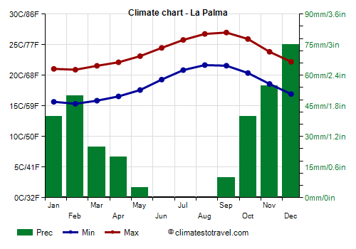
temperatures are very mild: highs are around 21/22 °C (70/72 °F) from December to April and 26/27 °C (79/81 °F) from July to October.
The temperature generally tends to stay around the average, however, from December to March, there can be some
cool days, with highs below 20 °C (68 °F). On the coldest days of the year, which typically occur in February, the temperature typically drops to 11/12 °C (52/54 °F) at night, while the maximum remains around 16/17 °C (61/63 °F). The cold record from 1980 onwards is 10 °C (50 °F), recorded in March 1988 and 1993 and in January 1994.
On the other hand, the days of
calima, characterized by abnormal heat and light wind, due to
hot air masses from Africa, are relatively rare, and are more frequent in spring and summer: in practice, these are the only days when the temperature exceeds 30 °C (86 °F) and the heat is unpleasant.
However, here and in El Hierro, the heat is felt less often and with less intensity than in the other Canary Islands. On the hottest days of the year, the temperature typically reaches 30/32 °C (86/90 °F). The record is 38.5 °C (101 °F), recorded in July 2007.

On the coast, the amount of
rain that falls in a year is not very high: at the airport, it is equal to 330 millimeters (13 inches), most of which occurring between October and March, that is, the period when the Canary Islands can be reached by some Atlantic depressions, with a maximum in November and December. However, from November to March there can sometimes be heavy rains.
In the interior, the temperature becomes naturally lower with increasing altitude: at 600 meters (2,000 feet), average maximum temperatures are around 16 °C (61 °F) in winter and 24/25 °C (75/77 °F) in summer. On inland slopes, rainfall is more abundant as well, and thick forests of pine, laurel and other species are found (on this island, there is a large biodiversity). In the wettest areas, rainfall exceeds 1,000 mm (40 in) per year.
The amount of
sunshine in La Palma is quite good in winter, as there are several sunny days, while in the rest of the year, cloud banks can form on the Atlantic and then reach the island. The annual total is lower than that of the other Canary Islands.

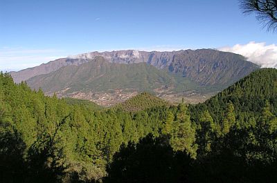
La Palma is a volcanic island; the southern part of the island is covered by a ridge of volcanic craters, among which stands
Cumbre Vieja, an active volcano, 1,949 meters (6,394 feet) high, while the central part is occupied by the large
Caldera de Taburiente, protected in a national park.
On the edge of the caldera, we find the highest point of the island,
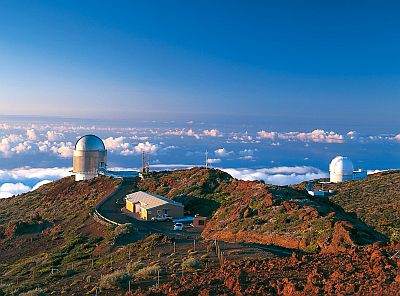
Roque de los Muchachos, 2,423 meters (7,949 feet) above sea level. Being above the altitude where the trade winds blow, it is generally above the clouds, and this is why an astronomical observatory was built here, the
Gran Telescopio Canarias. From the top you can see, scattered on the ocean, other islands of the Canaries (Tenerife, La Gomera and El Hierro). At this altitude, winter is cold, with highs around 7/8 °C (45/46 °F) and lows near the freezing point; sometimes, snow can fall, even abundant. In January 1990, the temperature dropped to -8 °C (17.5 °F). The wind can exceed 100 kph (60 mph), especially in the cold half of the year.
In summer, the temperatures are mild or pleasantly warm during the day (but with a very strong sun, which requires adequate protection, like sunglasses and a hat) and cool at night. However, on the hottest days the temperature can approach 30 °C (86 °F).
To get an idea of the climate of the summit, you can refer to the astronomical observatory of
Izaña, which is located on the island of Tenerife, at 2,390 meters (7,841 feet) above sea level.

The
sea in La Palma is quite cold in winter, though not prohibitively, and becomes warm enough for swimming from August to October. The island is located at a low latitude, almost at the Tropic, but on this side of the Atlantic Ocean, a cold current flows, however, in this western part of the Canary Islands, the sea is slightly warmer than in the east, where the current is stronger. The sea temperature ranges from 19 °C (66 °F) in March to 24 °C (75 °F) in September and October.
Best Time
The best time for a beach holiday in La Palma is from
May to mid-October. In the first part (May-June), the air temperature is a bit lower and the sea is a bit colder, but the days are slightly longer. In the Canaries, the days in summer are shorter than in Europe (while they are longer in winter), but because of the time zone adopted, the sun sets late enough anyway.
If you want to visit cities and go on excursions to the interior, you can choose April, May and the first half of October.
In winter, you will appreciate the mild temperatures and you can often sunbathe, although we can not exclude some days of bad weather. If you want, you can combine a hike in the mountains, in search of the snow, with an afternoon at the beach.
What to pack in the suitcase
In winter: bring light clothes for the day, a sweater and a jacket for the evening, and possibly a raincoat or umbrella. When going mountain climbing, bring a down jacket, a hat, gloves, and hiking shoes.
In summer: bring summer clothes, but also a scarf for the wind, a light sweatshirt, a light jacket for the evening and for windy afternoons. When going mountain climbing, bring hiking shoes, and a sweatshirt and a jacket for the highest elevations.
The following weather data was recorded at the airport, which is located on the east coast, not far from the city of Santa Cruz de La Palma.
Roque de los Muchachos - Climate data
In La Palma, the
average temperature of the coldest month (February) is of
18.1 °C, that of the warmest month (September) is of
24.3 °C. Here are the average temperatures.
La Palma - Average temperatures (1991-2020) |
| Month | Min | Max | Mean |
|---|
| January | 15.7 | 21.1 | 18.4 |
|---|
| February | 15.4 | 20.9 | 18.1 |
|---|
| March | 15.9 | 21.6 | 18.7 |
|---|
| April | 16.6 | 22.1 | 19.4 |
|---|
| May | 17.6 | 23.1 | 20.4 |
|---|
| June | 19.3 | 24.5 | 21.9 |
|---|
| July | 20.9 | 25.8 | 23.3 |
|---|
| August | 21.7 | 26.8 | 24.2 |
|---|
| September | 21.6 | 27 | 24.3 |
|---|
| October | 20.4 | 25.9 | 23.2 |
|---|
| November | 18.6 | 23.8 | 21.2 |
|---|
| December | 16.9 | 22.2 | 19.6 |
|---|
| Year | 18.4 | 23.8 | 21.05 |
|---|
amounts to
330 millimeters per year: it is therefore scarce. It ranges from
0 millimeters in the driest months (June, July, August) to
75 millimeters in the wettest one (December). Here is the average precipitation.
La Palma - Average precipitation| Month | Days |
|---|
| January | 40 | 5 |
|---|
| February | 50 | 4 |
|---|
| March | 25 | 3 |
|---|
| April | 20 | 3 |
|---|
| May | 5 | 1 |
|---|
| June | 0 | 0 |
|---|
| July | 0 | 0 |
|---|
| August | 0 | 0 |
|---|
| September | 10 | 2 |
|---|
| October | 40 | 5 |
|---|
| November | 55 | 7 |
|---|
| December | 75 | 7 |
|---|
| Year | 330 | 38 |
|---|
The
sea temperature ranges from
19 °C in March to
24 °C in September, October. Here are the average sea temperatures.
La Palma - Sea temperature| Month |
|---|
| January | 20 |
|---|
| February | 19.5 |
|---|
| March | 19 |
|---|
| April | 19.5 |
|---|
| May | 20.5 |
|---|
| June | 21.5 |
|---|
| July | 22.5 |
|---|
| August | 23.5 |
|---|
| September | 24 |
|---|
| October | 24 |
|---|
| November | 22.5"> |
|---|
| December | 21 |
|---|
| Year | 21.5 |
|---|
There are on average around 2145
sunshine hours per year. Here are the average hours of sunshine per day.
La Palma - Sunshine hours| Month | Average | Total |
|---|
| January | 4.5 | 145 |
|---|
| February | 5.5 | 150 |
|---|
| March | 6 | 185 |
|---|
| April | 6 | 180 |
|---|
| May | 6.5 | 195 |
|---|
| June | 7 | 205 |
|---|
| July | 7.5 | 235 |
|---|
| August | 7 | 220 |
|---|
| September | 6 | 185 |
|---|
| October | 5.5 | 175 |
|---|
| November | 4.5 | 135 |
|---|
| December | 4.5 | 140 |
|---|
| Year | 5.9 | 2145 |
|---|
La Palma - Weather by month
Based on the period 1991-2020
January is generally a warm month. The average temperature is of
18.4 °C, with a minimum of
15.7 °C and a maximum of
21.1 °C.

On the coldest nights of the month, the temperature usually drops to around
13.5 °C. However, it dropped to
10.2 °C in January 1994.

On the warmest days of the month, the temperature usually reaches around
24 °C. However, it reached
27.2 °C in January 2017.

Precipitation amounts to
40 mm, distributed over 5 days.
The day lasts on average 10 hours and 30 minutes.

There are on average 4.5 hours of sunshine per day. So, the sun shines 45% of the time.
The average humidity is 65%.
The average wind speed is of
15.1 kph.

The average sea temperature is of
19.9 °C. Therefore, the sea is very cool for swimming.
February, the coldest month of the year, is generally a warm month. The average temperature is of
18.1 °C, with a minimum of
15.4 °C and a maximum of
20.9 °C.

On the coldest nights of the month, the temperature usually drops to around
13 °C. However, it dropped to
10.9 °C in February 1992.

On the warmest days of the month, the temperature usually reaches around
24.5 °C. However, it reached
30.4 °C in February 2020.

Precipitation amounts to
50 mm, distributed over 4 days.
The day lasts on average 11 hours and 10 minutes.

There are on average 5.5 hours of sunshine per day. So, the sun shines 47% of the time.
The average humidity is 66%.
The average wind speed is of
16.8 kph.

The average sea temperature is of
19.3 °C. Therefore, the sea is very cool for swimming.
March is generally a warm month. The average temperature is of
18.7 °C, with a minimum of
15.9 °C and a maximum of
21.6 °C.

On the coldest nights of the month, the temperature usually drops to around
13.5 °C. However, it dropped to
10.2 °C in March 1993.

On the warmest days of the month, the temperature usually reaches around
26 °C. However, it reached
34.1 °C in March 2017.

Precipitation amounts to
25 mm, distributed over 3 days.
The day lasts on average 12 hours and 0 minutes.

There are on average 6 hours of sunshine per day. So, the sun shines 49% of the time.
The average humidity is 66%.
The average wind speed is of
17 kph.

The average sea temperature is of
19.2 °C. Therefore, the sea is very cool for swimming.
April is generally a warm month. The average temperature is of
19.4 °C, with a minimum of
16.6 °C and a maximum of
22.1 °C.

On the coldest nights of the month, the temperature usually drops to around
14 °C. However, it dropped to
12.4 °C in April 1994.

On the warmest days of the month, the temperature usually reaches around
25 °C. However, it reached
36.6 °C in April 2008.

Precipitation amounts to
20 mm, distributed over 3 days.
The day lasts on average 12 hours and 55 minutes.

There are on average 6 hours of sunshine per day. So, the sun shines 46% of the time.
The average humidity is 66%.
The average wind speed is of
17.2 kph.

The average sea temperature is of
19.6 °C. Therefore, the sea is very cool for swimming.
May is generally a warm month. The average temperature is of
20.4 °C, with a minimum of
17.6 °C and a maximum of
23.1 °C.

On the coldest nights of the month, the temperature usually drops to around
15.5 °C. However, it dropped to
13.4 °C in May 1993.

On the warmest days of the month, the temperature usually reaches around
26 °C. However, it reached
32.4 °C in May 2007.

Precipitation amounts to only
5 mm, and all occurs in one day.
The day lasts on average 13 hours and 35 minutes.

There are on average 6.5 hours of sunshine per day. So, the sun shines 46% of the time.
The average humidity is 67%.
The average wind speed is of
16.9 kph.

The average sea temperature is of
20.4 °C. Therefore, the sea is cool for swimming.
June is generally a warm month. The average temperature is of
21.9 °C, with a minimum of
19.3 °C and a maximum of
24.5 °C.

On the coldest nights of the month, the temperature usually drops to around
17.5 °C. However, it dropped to
16.2 °C in June 1992.

On the warmest days of the month, the temperature usually reaches around
26.5 °C. However, it reached
29.4 °C in June 2013.

Precipitation amounts to only
0 mm, so on average it never rains in the whole month.
The day lasts on average 14 hours and 0 minutes. June 21, the summer solstice, is the longest day of the year in the Northern Hemisphere.

There are on average 7 hours of sunshine per day. So, the sun shines 49% of the time.
The average humidity is 69%.
The average wind speed is of
18.6 kph.

The average sea temperature is of
21.6 °C. Therefore, the sea is cool for swimming.
July is generally a warm to hot month. The average temperature is of
23.3 °C, with a minimum of
20.9 °C and a maximum of
25.8 °C.

On the coldest nights of the month, the temperature usually drops to around
19.5 °C. However, it dropped to
17.9 °C in July 1991.

On the warmest days of the month, the temperature usually reaches around
29 °C. However, it reached
38.4 °C in July 2007.

Precipitation amounts to only
0 mm, so on average it never rains in the whole month.
The day lasts on average 13 hours and 50 minutes.

There are on average 7.5 hours of sunshine per day. So, the sun shines 55% of the time.
The average humidity is 69%.
The average wind speed is of
22.6 kph.

The average sea temperature is of
22.5 °C. Therefore, the sea can be considered barely acceptable for swimming.
August is generally a warm to hot month. The average temperature is of
24.2 °C, with a minimum of
21.7 °C and a maximum of
26.8 °C.

On the coldest nights of the month, the temperature usually drops to around
20 °C. However, it dropped to
16.7 °C in August 2011.

On the warmest days of the month, the temperature usually reaches around
29.5 °C. However, it reached
36 °C in August 2010.

Precipitation amounts to only
0 mm, so on average it never rains in the whole month.
The day lasts on average 13 hours and 5 minutes.

There are on average 7 hours of sunshine per day. So, the sun shines 54% of the time.
The average humidity is 70%.
The average wind speed is of
19.8 kph.

The average sea temperature is of
23.3 °C. Therefore, the sea can be considered barely acceptable for swimming.
September, the warmest month of the year, is generally a warm to hot month. The average temperature is of
24.3 °C, with a minimum of
21.6 °C and a maximum of
27 °C.

On the coldest nights of the month, the temperature usually drops to around
19.5 °C. However, it dropped to
16.4 °C in September 2007.

On the warmest days of the month, the temperature usually reaches around
30 °C. However, it reached
35.2 °C in September 2005.

Precipitation amounts to
10 mm, distributed over 2 days.
The day lasts on average 12 hours and 20 minutes.

There are on average 6 hours of sunshine per day. So, the sun shines 50% of the time.
The average humidity is 69%.
The average wind speed is of
14.9 kph.

The average sea temperature is of
24 °C. Therefore, the sea is warm enough for swimming.
October is generally a warm to hot month. The average temperature is of
23.2 °C, with a minimum of
20.4 °C and a maximum of
25.9 °C.

On the coldest nights of the month, the temperature usually drops to around
18 °C. However, it dropped to
15.3 °C in October 1999.

On the warmest days of the month, the temperature usually reaches around
29 °C. However, it reached
34.4 °C in October 2014.

Precipitation amounts to
40 mm, distributed over 5 days.
The day lasts on average 11 hours and 25 minutes.

There are on average 5.5 hours of sunshine per day. So, the sun shines 49% of the time.
The average humidity is 68%.
The average wind speed is of
13.8 kph.

The average sea temperature is of
23.8 °C. Therefore, the sea is warm enough for swimming.
November is generally a warm month. The average temperature is of
21.2 °C, with a minimum of
18.6 °C and a maximum of
23.8 °C.

On the coldest nights of the month, the temperature usually drops to around
15.5 °C. However, it dropped to
11 °C in November 2001.

On the warmest days of the month, the temperature usually reaches around
28 °C. However, it reached
31.6 °C in November 1995.

Precipitation amounts to
55 mm, distributed over 7 days.
The day lasts on average 10 hours and 40 minutes.

There are on average 4.5 hours of sunshine per day. So, the sun shines 42% of the time.
The average humidity is 67%.
The average wind speed is of
15.1 kph.

The average sea temperature is of
22.5 °C. Therefore, the sea can be considered barely acceptable for swimming.
December is generally a warm month. The average temperature is of
19.6 °C, with a minimum of
16.9 °C and a maximum of
22.2 °C.

On the coldest nights of the month, the temperature usually drops to around
14.5 °C. However, it dropped to
11.8 °C in December 1992.

On the warmest days of the month, the temperature usually reaches around
25.5 °C. However, it reached
29 °C in December 2019.

Precipitation amounts to
75 mm, distributed over 7 days.
The day lasts on average 10 hours and 20 minutes. December 21, the winter solstice, is the shortest day of the year in the Northern Hemisphere.

There are on average 4.5 hours of sunshine per day. So, the sun shines 44% of the time.
The average humidity is 66%.
The average wind speed is of
15.2 kph.

The average sea temperature is of
21 °C. Therefore, the sea is cool for swimming.