Select units of measurement for the temperature and rainfall tables (metric or imperial).
Average weather, temperature, rainfall, sunshine hours

Index
Introduction
On the coasts of Gran Canaria, a round-shaped island, the climate is
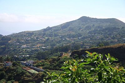
subtropical oceanic, that is, very mild and sunny most of the year. Winters are mild and spring-like, while summers are sunny and warm; there is also little rainfall, concentrated in the period from October to March. In inland areas, on the other hand, the climate varies according to altitude and slope exposure. In fact, the slopes exposed to the northeast trade winds receive a moderate amount of
rain and are green, while rainfall is scarce on the southern slopes, often below 150 millimeters (6 inches) per year, to the point that the island appears divided in two, the northern part being verdant and the southern one almost desert.

The prevailing winds, the
trade winds, not only make the northern slopes more humid, but also temper the heat along the coasts during summer; these winds blow more intensely in the afternoon, when they are often moderate or even quite strong.
The temperature generally tends to stay around the average, however, from December to March, there can be some
cool days, with highs below 20 °C (68 °F). On the coldest days of the year, which typically occur in February, the temperature typically drops to 10/11 °C (50/52 °F) at night, while the maximum remains around 17/18 °C (63/64 °F).
On the other hand, the days of
calima, characterized by abnormal heat and light wind, due to
hot air masses from Africa, are relatively rare, and are more frequent in spring and summer: in practice, these are the only days when the temperature exceeds 30 °C (86 °F) and the heat is unpleasant. The
calima is also felt on the highlands, and often even more so than in the plains, since warm air is lighter and tends to rise, while the coast can be mitigated by the sea.
The coasts
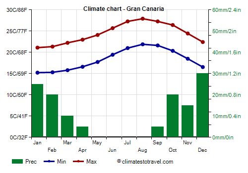
Along the coasts, and therefore also in the largest cities, such as Las Palmas de Gran Canaria, Ingenio and Telde, daytime temperatures are very mild in winter, with highs around 21 °C (70 °F) in January and February, and warm in summer, with highs around 27/28 °C (81/82 °F) from July to September.
At the airport, the post-1980 heat record is 39 °C (102 °F), set in July 2007, in August 2010 and in September 1987 and 2006. The cold record is 9.5 °C (49 °F), set in February 1994.
The
rain pattern is Mediterranean, which means that the bulk of the rain falls between October and March, since it is the time when the Canary Islands can be reached by some Atlantic fronts; in summer, on the contrary, it hardly ever rains. The total amount of rain that falls in a year is still very low, below 150 millimeters (6 inches), so it's at desert levels. Even in autumn and winter, weeks can pass without a drop of water falling, although there can occasionally be more intense rains, as happened in the past from October to February.

The amount of
sunshine in Gran Canaria is very good throughout the year, however, in addition to the low pressure systems that can pass over the island from October to March, in summer, cloud banks can form on the Atlantic Ocean and reach the island. On the north coast (therefore also in Las Palmas), and especially on the mountain slopes exposed to the north, local clouds and fogs can form. The cloud cover that forms on the northern slopes is called by locals "
panza de burro" (belly of the donkey).
The southern coast is therefore the sunniest one.
The
sea in Gran Canaria is quite cold in winter, though not prohibitively, and remains cool in summer. In fact, the island is located at a low latitude, almost at the Tropic, but in this part of the Atlantic Ocean, a cold current flows. Those who live on the island usually swim in the sea even in winter because they are accustomed to it, and also Nordic tourists or those who do not suffer from the cold. Anyway, the sea temperature ranges from 19 °C (66 °F) between February and April to 23.5 °C (74 °F) in September and October.
The capital, Las Palmas, is located in the north-east of the island, where also the beach called
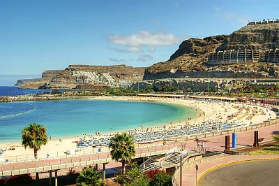
Playa de Las Canteras is located; other famous beaches are located in the east and the south of the island, where also the Maspalomas Dunes are found, a small sand desert along the coast.
Inland areas
In
inland areas, the weather gets cooler as you go up in altitude, and as mentioned, the north side has a cool and humid microclimate, with rains of a certain importance from October to March, and also more frequent cloudiness and mists, so much so that there are several towns situated in a green environment. At 600/700 meters (2,000/2,300 feet), the daytime temperatures are about 16 °C (61 °F) in winter (and in unheated houses it's cold...) and 25 °C (77 °F) in summer.
The highest peak is
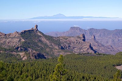
Pico de las Nieves, 1,949 meters (6,394 feet) high, located in the center of the island. At this altitude, winter is cold, in fact, highs hover around 10 °C (50 °F) and lows are just above freezing (0 °C or 32 °F); sometimes, the temperature can drop below freezing and even snow can fall. The wind can be strong too. In summer, the temperatures are pleasantly warm during the day (but the sun is very strong, so it requires adequate protection, with a hat and sunglasses) and cool at night. From the top of the mountain, you can see Mount Teide, the highest peak of Tenerife and of all the Canary Islands.

Best Time
The best time for a beach holiday in Gran Canaria is from
May to mid-October. In the first period (May-June), the air temperature is a bit lower and the sea is a bit colder, but the days are slightly longer.
If you want to visit cities and go on excursions to the interior of the island, you can choose April, May and the first half of October.
In winter, you will appreciate the mild temperatures and you can often sunbathe, although we can not exclude some days of bad weather. You can also combine a trip to Pico de las Nieves, in search of the snow, with an afternoon on the beach. On the other hand, weather disturbances can bring high waves, generated by winds (from the west or the south) different from the typical trade winds, and that can be appreciated by surfers.
What to pack in the suitcase
In winter: bring light clothes for the day, a sweater and a jacket for the evening, and possibly a raincoat or umbrella. When going to Pico de las Nieves, bring a down jacket, a hat, gloves, and hiking boots.
In summer: bring summer clothes, but also a scarf for the wind, a light sweatshirt, a light jacket for the evening and windy afternoons; comfortable shoes for hiking. When going to Pico de las Nieves, bring hiking shoes, and a sweatshirt and a jacket for the evening.
The following meteorological data were recorded at Gran Canaria Airport, which is located in the eastern part of the island, near Ingenio.
Gran Canaria - Climate data
In Gran Canaria, the
average temperature of the coldest month (January) is of
18.2 °C, that of the warmest month (August) is of
24.9 °C. Here are the average temperatures.
Gran Canaria - Average temperatures (1991-2020) |
| Month | Min | Max | Mean |
|---|
| January | 15.2 | 21.1 | 18.2 |
|---|
| February | 15.3 | 21.4 | 18.3 |
|---|
| March | 15.8 | 22.2 | 19 |
|---|
| April | 16.6 | 23 | 19.8 |
|---|
| May | 17.7 | 24.1 | 20.9 |
|---|
| June | 19.4 | 25.7 | 22.6 |
|---|
| July | 21 | 27.3 | 24.1 |
|---|
| August | 21.9 | 27.9 | 24.9 |
|---|
| September | 21.6 | 27.3 | 24.5 |
|---|
| October | 20.4 | 26.4 | 23.4 |
|---|
| November | 18.5 | 24.4 | 21.5 |
|---|
| December | 16.5 | 22.4 | 19.5 |
|---|
| Year | 18.4 | 24.5 | 21.35 |
|---|
amounts to
135 millimeters per year: it is therefore at a desert level. It ranges from
0 millimeters in the driest months (May, June, July, August) to
30 millimeters in the wettest one (December). Here is the average precipitation.
Gran Canaria - Average precipitation| Month | Days |
|---|
| January | 25 | 3 |
|---|
| February | 20 | 3 |
|---|
| March | 10 | 2 |
|---|
| April | 5 | 1 |
|---|
| May | 0 | 0 |
|---|
| June | 0 | 0 |
|---|
| July | 0 | 0 |
|---|
| August | 0 | 0 |
|---|
| September | 5 | 1 |
|---|
| October | 20 | 3 |
|---|
| November | 15 | 3 |
|---|
| December | 30 | 4 |
|---|
| Year | 135 | 21 |
|---|
The
sea temperature ranges from
19 °C in February, March, April to
23.5 °C in September, October. Here are the average sea temperatures.
Gran Canaria - Sea temperature| Month |
|---|
| January | 19.5 |
|---|
| February | 19 |
|---|
| March | 19 |
|---|
| April | 19 |
|---|
| May | 20 |
|---|
| June | 21 |
|---|
| July | 22 |
|---|
| August | 23 |
|---|
| September | 23.5 |
|---|
| October | 23.5 |
|---|
| November | 22"> |
|---|
| December | 20.5 |
|---|
| Year | 21 |
|---|
There are on average around 2815
sunshine hours per year. Here are the average hours of sunshine per day.
Gran Canaria - Sunshine hours| Month | Average | Total |
|---|
| January | 6 | 190 |
|---|
| February | 7 | 195 |
|---|
| March | 7.5 | 230 |
|---|
| April | 8 | 235 |
|---|
| May | 8.5 | 265 |
|---|
| June | 9 | 270 |
|---|
| July | 9.5 | 300 |
|---|
| August | 9.5 | 300 |
|---|
| September | 8.5 | 250 |
|---|
| October | 7 | 215 |
|---|
| November | 6 | 180 |
|---|
| December | 6 | 185 |
|---|
| Year | 7.7 | 2815 |
|---|
Gran Canaria - Weather by month
Based on the period 1991-2020
January, the coldest month of the year, is generally a warm month. The average temperature is of
18.2 °C, with a minimum of
15.2 °C and a maximum of
21.1 °C.

On the coldest nights of the month, the temperature usually drops to around
12 °C. However, it dropped to
10.8 °C in January 2020.

On the warmest days of the month, the temperature usually reaches around
24.5 °C. However, it reached
29.5 °C in January 2010.

Precipitation amounts to
25 mm, distributed over 3 days.
The day lasts on average 10 hours and 35 minutes.

There are on average 6 hours of sunshine per day. So, the sun shines 58% of the time.
The average humidity is 66%.
The average wind speed is of
17.8 kph.

The average sea temperature is of
19.4 °C. Therefore, the sea is very cool for swimming.
February is generally a warm month. The average temperature is of
18.3 °C, with a minimum of
15.3 °C and a maximum of
21.4 °C.

On the coldest nights of the month, the temperature usually drops to around
12.5 °C. However, it dropped to
9.4 °C in February 1994.

On the warmest days of the month, the temperature usually reaches around
25 °C. However, it reached
30.9 °C in February 2010.

Precipitation amounts to
20 mm, distributed over 3 days.
The day lasts on average 11 hours and 10 minutes.

There are on average 7 hours of sunshine per day. So, the sun shines 62% of the time.
The average humidity is 66%.
The average wind speed is of
21.6 kph.

The average sea temperature is of
18.8 °C. Therefore, the sea is very cool for swimming.
March is generally a warm month. The average temperature is of
19 °C, with a minimum of
15.8 °C and a maximum of
22.2 °C.

On the coldest nights of the month, the temperature usually drops to around
13 °C. However, it dropped to
10.1 °C in March 2011.

On the warmest days of the month, the temperature usually reaches around
27 °C. However, it reached
31.6 °C in March 2001.

Precipitation amounts to
10 mm, distributed over 2 days.
The day lasts on average 12 hours and 0 minutes.

There are on average 7.5 hours of sunshine per day. So, the sun shines 62% of the time.
The average humidity is 66%.
The average wind speed is of
23.4 kph.

The average sea temperature is of
18.8 °C. Therefore, the sea is very cool for swimming.
April is generally a warm month. The average temperature is of
19.8 °C, with a minimum of
16.6 °C and a maximum of
23 °C.

On the coldest nights of the month, the temperature usually drops to around
14 °C. However, it dropped to
12.4 °C in April 1991.

On the warmest days of the month, the temperature usually reaches around
28 °C. However, it reached
34.3 °C in April 2013.

Precipitation amounts to only
5 mm, and all occurs in one day.
The day lasts on average 12 hours and 55 minutes.

There are on average 8 hours of sunshine per day. So, the sun shines 60% of the time.
The average humidity is 66%.
The average wind speed is of
26.2 kph.

The average sea temperature is of
19.2 °C. Therefore, the sea is very cool for swimming.
May is generally a warm month. The average temperature is of
20.9 °C, with a minimum of
17.7 °C and a maximum of
24.1 °C.

On the coldest nights of the month, the temperature usually drops to around
15.5 °C. However, it dropped to
13 °C in May 1993.

On the warmest days of the month, the temperature usually reaches around
28.5 °C. However, it reached
35 °C in May 2012.

Precipitation amounts to only
0 mm, so on average it never rains in the whole month.
The day lasts on average 13 hours and 35 minutes.

There are on average 8.5 hours of sunshine per day. So, the sun shines 63% of the time.
The average humidity is 67%.
The average wind speed is of
28.1 kph.

The average sea temperature is of
20 °C. Therefore, the sea is very cool for swimming.
June is generally a warm to hot month. The average temperature is of
22.6 °C, with a minimum of
19.4 °C and a maximum of
25.7 °C.

On the coldest nights of the month, the temperature usually drops to around
17 °C. However, it dropped to
15.9 °C in June 2007.

On the warmest days of the month, the temperature usually reaches around
30 °C. However, it reached
36.9 °C in June 2010.

Precipitation amounts to only
0 mm, so on average it never rains in the whole month.
The day lasts on average 13 hours and 55 minutes. June 21, the summer solstice, is the longest day of the year in the Northern Hemisphere.

There are on average 9 hours of sunshine per day. So, the sun shines 65% of the time.
The average humidity is 68%.
The average wind speed is of
32.6 kph.

The average sea temperature is of
21.2 °C. Therefore, the sea is cool for swimming.
July is generally a warm to hot month. The average temperature is of
24.1 °C, with a minimum of
21 °C and a maximum of
27.3 °C.

On the coldest nights of the month, the temperature usually drops to around
19.5 °C. However, it dropped to
18 °C in July 1991.

On the warmest days of the month, the temperature usually reaches around
33 °C. However, it reached
39 °C in July 2007.

Precipitation amounts to only
0 mm, so on average it never rains in the whole month.
The day lasts on average 13 hours and 40 minutes.

There are on average 9.5 hours of sunshine per day. So, the sun shines 71% of the time.
The average humidity is 66%.
The average wind speed is of
40 kph.

The average sea temperature is of
22 °C. Therefore, the sea is cool for swimming.
August, the warmest month of the year, is generally a warm to hot month. The average temperature is of
24.9 °C, with a minimum of
21.9 °C and a maximum of
27.9 °C.

On the coldest nights of the month, the temperature usually drops to around
20.5 °C. However, it dropped to
18 °C in August 1991.

On the warmest days of the month, the temperature usually reaches around
32.5 °C. However, it reached
39 °C in August 2010.

Precipitation amounts to only
0 mm, so on average it never rains in the whole month.
The day lasts on average 13 hours and 5 minutes.

There are on average 9.5 hours of sunshine per day. So, the sun shines 74% of the time.
The average humidity is 67%.
The average wind speed is of
36.8 kph.

The average sea temperature is of
22.8 °C. Therefore, the sea can be considered barely acceptable for swimming.
September is generally a warm to hot, muggy month. The average temperature is of
24.5 °C, with a minimum of
21.6 °C and a maximum of
27.3 °C.

On the coldest nights of the month, the temperature usually drops to around
19.5 °C. However, it dropped to
17 °C in September 1992.

On the warmest days of the month, the temperature usually reaches around
31 °C. However, it reached
39 °C in September 2006.

Precipitation amounts to only
5 mm, and all occurs in one day.
The day lasts on average 12 hours and 20 minutes.

There are on average 8.5 hours of sunshine per day. So, the sun shines 67% of the time.
The average humidity is 70%. Hence, the air is normally humid.
The average wind speed is of
27.1 kph.

The average sea temperature is of
23.5 °C. Therefore, the sea can be considered barely acceptable for swimming.
October is generally a warm to hot month. The average temperature is of
23.4 °C, with a minimum of
20.4 °C and a maximum of
26.4 °C.

On the coldest nights of the month, the temperature usually drops to around
17.5 °C. However, it dropped to
14.8 °C in October 1993.

On the warmest days of the month, the temperature usually reaches around
31 °C. However, it reached
37 °C in October 2017.

Precipitation amounts to
20 mm, distributed over 3 days.
The day lasts on average 11 hours and 30 minutes.

There are on average 7 hours of sunshine per day. So, the sun shines 61% of the time.
The average humidity is 70%.
The average wind speed is of
19.6 kph.

The average sea temperature is of
23.3 °C. Therefore, the sea can be considered barely acceptable for swimming.
November is generally a warm month. The average temperature is of
21.5 °C, with a minimum of
18.5 °C and a maximum of
24.4 °C.

On the coldest nights of the month, the temperature usually drops to around
15.5 °C. However, it dropped to
12.8 °C in November 1991.

On the warmest days of the month, the temperature usually reaches around
29 °C. However, it reached
36.2 °C in November 1997.

Precipitation amounts to
15 mm, distributed over 3 days.
The day lasts on average 10 hours and 50 minutes.

There are on average 6 hours of sunshine per day. So, the sun shines 55% of the time.
The average humidity is 67%.
The average wind speed is of
18.7 kph.

The average sea temperature is of
22.1 °C. Therefore, the sea is cool for swimming.
December is generally a warm month. The average temperature is of
19.5 °C, with a minimum of
16.5 °C and a maximum of
22.4 °C.

On the coldest nights of the month, the temperature usually drops to around
14 °C. However, it dropped to
12 °C in December 1991.

On the warmest days of the month, the temperature usually reaches around
26 °C. However, it reached
29 °C in December 1995.

Precipitation amounts to
30 mm, distributed over 4 days.
The day lasts on average 10 hours and 25 minutes. December 21, the winter solstice, is the shortest day of the year in the Northern Hemisphere.

There are on average 6 hours of sunshine per day. So, the sun shines 57% of the time.
The average humidity is 68%.
The average wind speed is of
17 kph.

The average sea temperature is of
20.6 °C. Therefore, the sea is cool for swimming.