![]() Climate chart - La Paz (Bolivia)
Climate chart - La Paz (Bolivia)
In La Paz (or
Chuqi Yapu in Aymara), there is an
subtropical mountain climate in the central areas and at lower altitudes, while in the higher areas, we can say that there is a
subpolar tundra climate, given that the temperature of the warmest month does not exceed 10 °C (50 °F), and therefore the trees cannot grow, even though the winter is not as cold as in the sub-polar areas.
The city, whose full name is
Nuestra Señora de La Paz, is the capital of Bolivia and is located on the Andean plateau, at 16 degrees south latitude.
Daytime
temperatures are stable throughout the year, while during the austral winter, from May to August, it gets cold at night, especially in the upper part of the city, where there are regularly frosts, and sometimes the temperature can even drop below -10 °C (14 °F). However, the winter is dry and sunny, while during the austral summer, from December to March, the rains are very frequent, and sometimes can cause landslides.
At night,
fog can form all year round, but especially in summer.
Although the winter is dry, sometimes it can even
snow, as happened on July 4, 2015, more significantly in the upper part of La Paz.
La Paz is the highest capital in the world, however, the altitude of the city varies a lot, that is, from 3,200 to 4,300 meters (10,500 to 14,100 feet).

First, let's see the meteorological data recorded at the airport, which is located in the upper part, called "El Alto", at 4,000 meters (13,100 ft).
El Alto - Average temperatures (1991-2020) | Month | Min (°C) | Max (°C) | Mean (°C) | Min (°F) | Max (°F) | Mean (°F) |
|---|
| January | 4.2 | 14.8 | 9.5 | 40 | 59 | 49.1 |
|---|
| February | 4.2 | 14.9 | 9.5 | 39 | 59 | 49.1 |
|---|
| March | 3.4 | 15.1 | 9.2 | 38 | 59 | 48.6 |
|---|
| April | 1.4 | 15.3 | 8.4 | 34 | 60 | 47 |
|---|
| May | -2 | 15.3 | 6.7 | 28 | 60 | 44 |
|---|
| June | -3.8 | 14.5 | 5.4 | 25 | 58 | 41.7 |
|---|
| July | -4.1 | 14.3 | 5.1 | 25 | 58 | 41.2 |
|---|
| August | -3.1 | 15.3 | 6.1 | 26 | 60 | 43 |
|---|
| September | -0.7 | 15.9 | 7.6 | 31 | 61 | 45.6 |
|---|
| October | 1.5 | 16.5 | 9 | 35 | 62 | 48.1 |
|---|
| November | 2.4 | 17.2 | 9.8 | 36 | 63 | 49.7 |
|---|
| December | 3.8 | 16.3 | 10 | 39 | 61 | 50 |
|---|
| Year | 0.6 | 15.5 | 8 | 33 | 59.8 | 46.5 |
|---|
In the vicinity of La Paz is the
Cordillera Real, where the second and third highest mountains in Bolivia are located, Illimani, 6,438 meters (21,122 feet), and Ancohuma (or Janq'u Uma), 6,427 meters (21,085 ft).
About 50 km (30 mi) to the north-west is Lake Titicaca, whose shores are located at 3,800 meters (12,465 ft).
Best Time
The
best time to visit La Paz is from April to October. Winter, from May to August, is dry and sunny, although it gets cold at night. In April, September and October, the rains are a little more frequent, but nights are a little milder.
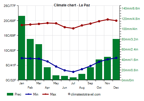
Let us now see the meteorological data of the central part of the city, located at 3,650 meters (11,975 ft) above sea level.
La Paz - Climate data
The
average temperature of the coldest month (July) is of 10.1 °C (50.2 °F), that of the warmest month (December) is of 13.8 °C (56.8 °F). Here are the average temperatures.
La Paz - Average temperatures (1981-2010) | Month | Min (°C) | Max (°C) | Mean (°C) | Min (°F) | Max (°F) | Mean (°F) |
|---|
| January | 7.4 | 18.5 | 13 | 45 | 65 | 55.3 |
|---|
| February | 7.3 | 18.7 | 13 | 45 | 66 | 55.4 |
|---|
| March | 7.2 | 18.9 | 13 | 45 | 66 | 55.5 |
|---|
| April | 6.3 | 19.2 | 12.8 | 43 | 67 | 55 |
|---|
| May | 4.6 | 19.1 | 11.9 | 40 | 66 | 53.3 |
|---|
| June | 3.3 | 17.8 | 10.6 | 38 | 64 | 51 |
|---|
| July | 2.8 | 17.4 | 10.1 | 37 | 63 | 50.2 |
|---|
| August | 3.7 | 18.4 | 11 | 39 | 65 | 51.9 |
|---|
| September | 4.8 | 19 | 11.9 | 41 | 66 | 53.4 |
|---|
| October | 6.2 | 19.8 | 13 | 43 | 68 | 55.4 |
|---|
| November | 7 | 20.4 | 13.7 | 45 | 69 | 56.7 |
|---|
| December | 7.5 | 20 | 13.8 | 46 | 68 | 56.8 |
|---|
| Year | 5.7 | 18.9 | 12.25 | 42.2 | 66.1 | 54 |
|---|
amounts to 525 millimeters (20.7 inches) per year: so, it is at an intermediate level. It ranges from 5 mm (0.2 in) in the driest month (July) to 125 mm (4.9 in) in the wettest one (January). Here is the average precipitation.
La Paz - Average precipitation| Month | Millimeters | Inches | Days |
|---|
| January | 125 | 4.9 | 21 |
|---|
| February | 80 | 3.1 | 17 |
|---|
| March | 70 | 2.8 | 15 |
|---|
| April | 25 | 1 | 9 |
|---|
| May | 9 | 0.4 | 4 |
|---|
| June | 8 | 0.3 | 2 |
|---|
| July | 5 | 0.2 | 2 |
|---|
| August | 12 | 0.5 | 4 |
|---|
| September | 25 | 1 | 7 |
|---|
| October | 40 | 1.6 | 11 |
|---|
| November | 45 | 1.8 | 11 |
|---|
| December | 80 | 3.1 | 16 |
|---|
| Year | 525 | 20.7 | 119 |
|---|
There are on average around 2435
sunshine hours per year. Here are the average hours of sunshine per day.
La Paz - Sunshine hours| Month | Average | Total |
|---|
January | 4.5 | 145 | February | 5.5 | 160 | March | 5.5 | 170 | April | 6.5 | 190 | May | 8 | 245 | June | 8 | 240 | July | 8 | 240 | August | 8 | 250 | September | 7.5 | 230 | October | 7 | 215 | November | 6 | 180 | December | 5.5 | 170 | Year | 6.7 | 2435 |